

There are some changes that arrive with noise and warning, and there are others that come quietly, with so little outward drama that people do not at first understand what has happened. A railroad was often that way. Before the first locomotive ever whistled through a country, the real decision had already been made by men with maps, profiles, levels, and ledgers. They measured grade and drainage, curvature and cost, probable freight and future traffic. Then, with the simple turning of a line on paper, they decided which town would live in the current of trade and which would stand just outside it. In places like Marshall County, where communities were still young and still fragile, that difference could mean almost everything.
Thatiswhythestoryofthe Arkinda–Ardmore line is not merely the story of an east– west railroad. It is the story of a county already altered once by the coming of steel, altered again by a second railroad whose purpose was larger and whose reach was wider, and altered at last by water when a later age of “progress” buried part of the country the railroad had helped create. It is the story of Oakland, which came first and believed its place secure; of Madill, which rose because the railroad chose it; of Aylesworth, whichwasbornalmost entirely from the railroad’s need and later destroyed by another great public work; and of the little depots and motorcars that made the railroad not an abstraction, but a daily fact in the lives of ordinary people.
To tell that story honestly, one must begin before the Arkinda–Ardmore line itself, and before Madill, and even before the first Frisco surveyor crossed this part of Indian Territory.
One must begin with Oakland.
Oakland belonged to the older order of things. It was not a railroad town. It was a frontier town, and like most frontier towns worth remembering, it grew from effort, patience, and the stubborn will of individuals rather than from corporate planning. Its founder, Richard Catesby Wiggs, was one of the most important early figures in the history of what is now Marshall County. He was born in Lexington, Kentucky, on February 17, 1838. When he was still a boy, his family moved west to Pettis County, Missouri, and by 1860 they were living in Grayson County, Texas. He was described as a tall man for that day, standing six feet, with dark hair and hazel eyes. His life, like the life of so many nineteenth-century southerners and westerners, was shaped by movement, conflict, and rebuilding.
WhentheCivilWarbegan, Wiggs enlisted on October 2, 1861, at Camp Reeves near Sherman, Texas, helping to form Company C of the Eleventh Texas Cavalry, the first company formed in Grayson County. The regiment was also known as Young’s Regiment. It was first sent into Indian Territory and fought at Chustenahlah on December 26, 1861. After that, it moved into Arkansas for the winter, then fought at Pea RidgeinMarch1862.Disease struck hard in those early campaigns. Typhoid, pneumonia, and measles thinned the ranks before many men ever had the chance to fall in battle. The regiment was dismounted, reorganized, andsentthroughthelongand grinding service that took it into Mississippi, Tennessee, Kentucky,andbeyond.Wiggs rose from second lieutenant to first lieutenant, was wounded severely in October 1863, spent months hospitalized in Georgia, and eventually returned. He and the regimentenduredRichmond, Murfreesboro,Chickamauga, the Atlanta campaign, and the long collapse of the Confederacy. On May 16, 1865, at Columbus, Mississippi, Wiggs was among the last organized remnant of his company to surrender. He signed as First Lieutenant R. C. Wiggs. Later memory would call him “Captain” Wiggs, and that was how local obituary and tradition preserved him, though the surviving military record places him at first lieutenant. Still, rank on paper is one thing and standing in a community another, and by the time his life was done, “Captain Wiggs” was the name by which history remembered him.
After the war he returned to Grayson County, Texas, married Elizabeth Warner, and fathered two sons, William WarnerWiggsandHugh Bulford Wiggs. Elizabeth died not long after the birth of the second child. In 1874, with two young sons and the unsettled future common to widowed men on the postwar frontier, Wiggs moved into Indian Territory and settled along Glasses Creek, just north of what became Oakland. There he established a farm and ranch of roughly two thousand acres, raising corn and cotton and grazing cattle. The settlement that grewtheretookitsnamefrom theoaktimberaroundit.Oak Land, later standardized to Oakland, was a practical name, but also a revealing one. The town quite literally grew out of those trees. They furnished the first homes, the first stores, the first rough furniture, the first public buildings.Itwasaplacehewn from the timber and held in place by labor.
Soon after arriving in Indian Territory, Wiggs married Georgia Ann Allen, a citizen of the Chickasaw Nation, on October 13, 1875. Tragedy returned swiftly. Georgia Ann died on November 7, 1876, while attempting to deliver their first child, who also died. In April 1886, Wiggs married Josie Lawson, and together they had a daughter, Mary Edna Wiggs. Over time, Wiggs’s life would touch not only local settlement but questions of law and tribal citizenship as well. After Congress in 1888 passed legislation declaring that Indian women who married white men became citizens of the United States, Wiggs later sought citizenship in the Chickasaw Nation by virtue of his marriage to Georgia AnnAllen.In1896,hefiledan application with the Dawes Commission on behalf of himself, his wife Josie, and their daughter Mary Edna. The Chickasaw Nation resisted the claim and litigated it. The Dawes Commission ruled in Wiggs’s favor. The Chickasaw Nation appealed. Federal courts upheld the ruling.Eventuallythematter reached the Supreme Court of the United States in The ChickasawNationv.Richard C.WiggsandtheDawesCommission, and Wiggs again prevailed. The significance of that decision reached beyond his own family. It established an important legal path for citizenship claims through intermarriage and carried broad implications for the tribes and the Dawes era. Wiggs later served as sheriff of Pickens County, as a member of the Chickasaw Legislature, and as clerk of Pickens County. Yet for all of that public service and legal significance, his most lasting work in local memory remained the founding of Oakland.
By 1881, Oakland had the first commissioned post office in what is now Marshall County. It became the countyseatofPickensCounty in the Chickasaw Nation. In 1882, Wiggs opened the Wiggs Hotel, described as a first-class establishment and favored by travelers and people of distinction. He also dug the first public water well. In 1884, Ed Sacra opened the first store. In 1895, Jess Grinstead, son of the first postmaster, William Grinstead, established the first newspaper in Marshall County there in Oakland, a paper that later moved to Madill and became the Madill Record. Ed Dillingham opened a substantial general store and dry goods business. The first church in the county was built there, shared by Methodists and members of the Church of Christ, and the same building doubled as the schoolhouse. That early school was a subscription school charging tuition, and its desks were fashioned from split oak logs with peg legs—furniture as rough and honest as the country itself.
By 1890, Oakland had become the leading settlement in the area. It had a two-story rock building with stores below and doctors’ and lawyers’ offices above. It had restaurants, drug stores, grocery stores, dry goods houses, dairies, and at one time as many as three cotton gins. It was the established town, the county seat town, the town with the first post office, the first newspaper, the first church, and the first school. It was, in every human sense that mattered in a pre-rail world, the center of the region. If one had stood there in the late 1890s and asked where the future lay, the answer would have seemed obvious.
Then the Frisco came, and the answer changed.
In 1900, the St. Louis and San Francisco Railway—better known to generations simply as the Frisco—began planning and building its north–south line from Sapulpa south toward Denison, Texas. Most people assumed that such a line would naturally go through Oakland. Why would it not? Oakland already existed. It already had people, businesses, a central role, and local consequence. But railroads did not honor seniority or sentiment. They honored grade, cost, drainage, curvature, and, above all, right-of-way. Whether the Frisco could not secure an acceptable rightof- way through Oakland or whether its planners simply preferred a route to the east, the result was the same. The line did not come through the established town. It passed roughly two miles east of it.
That decision changed Marshall County as surely as a flood or fire might have done. In the open country east of Oakland, the railroad establisheditsline,andanew town was formed—Madill. Named for a Frisco official, Madill rose from the prairie because the railroad needed a town there. Businesses in Oakland, understanding with painful speed what the railroad meant, began to move. Trade followed the rails. Population shifted. The current of commerce turned eastward. Oakland did not vanish because towns rarely vanish all at once, but its role changed fundamentally. It had been overtaken not by decline from within, but by a line of steel laid just beyond its edge.
And yet the irony of Marshall County’s railroad story is this: Oakland did not remain rail-less. Only two years after being bypassed on the north–south line, it found itself on an entirely different rail line.
That second line, the Arkinda–Ardmore route, was part of a broader, more ambitious design. The Frisco at the turn of the century was engagedinasweepingexpansion program, reaching into Oklahoma,Texas,Louisiana, and the Gulf Coast. The company’s vision from roughly 1896 to 1913 was not simply to hold scattered branch lines but to weave together a powerful regional system. It sought to connect interior trafficfromOklahoma,northern Texas, and farther west to eastern lines and southern coastal markets. Within that vision, the east–west route from Hope, Arkansas, to Ardmore, Indian Territory, mattered greatly.
The route’s corporate genealogy reflects that ambition. ItbeganastheArkansas and Choctaw Railway, incorporated on August 31, 1895. For a time, it was controlled by the Central Coal and Coke Company of Kansas City, Missouri, and extended only from Ashdown to Arkinda, Arkansas, about twenty-four miles. On June 11, 1901, control passed to the Choctaw Construction Company, which in turn was controlled by powerful railroad and coal interests. In 1902, the companyamendeditsarticles andbecametheSt.Louis,San Francisco and New Orleans Railway Company. On June 21, 1902, the stockholders of the Choctaw Construction Company agreed to sell their holdings to the St. Louis and San Francisco Railroad. Under aJuly8,1902,agreement, a syndicate financed the purchase and vested control of construction in the Frisco’s orbit. Construction plans were revised to provide for a line from Hope, Arkansas, to Ardmore, Indian Territory. By January 1, 1904, the Frisco effectively owned the company's securities, and on April 30, 1907, the property, rights, and franchises were formally conveyed to the St. Louis and San Francisco Railroad Company.
Construction itself took about twenty months, a remarkable pace considering the varied country the line crossed.Whencompleted,the line stretched roughly 222.7 miles from Hope to Ardmore by way of Hugo. It passed through Hope, Ashdown, Arkinda, and then westward through southeastern Oklahoma: Haworth, Idabel, Fort Towson, Hugo, Soper, Boswell, Bennington, Bokchito, Blue, Durant, Mead, Aylesworth, Madill, Oakland, and on toward Ardmore. At Hugo, it crossed the Frisco’s north–south line. At Madill it crossed the newer Frisco north-south, Texas Main Line. For a time, it also had a connection from Kiersey Junction to Texas Junction, removed in 1934. This was not a local convenience. It was an artery.
And it was built with purpose. The line was intended to gather traffic originating in Colorado, southern and western Oklahoma, and northern Texas and move it eastward toward Arkansas and, in the broader dream of Frisco planners, on toward Gulf Coast outlets and New Orleans. During those same years, the Frisco and the closely aligned Rock Island interests operated almost as a single system, and the Arkinda–Ardmore route was part of a larger strategy of expansion and consolidation that extended from Oklahoma into Texas and beyond. Not every part of that grand schemewascompleted.Some projected Mississippi and westernextensionsremained unrealized. Yet the line from Hope to Ardmore did get built, and for generations it mattered enormously.
In Marshall County, the line produced a more subtle and layered transformation than the north–south route had done. Oakland, though diminished, was placed once again upon a railroad. It gained access to freight, passenger, express, and mail service. But it received that service too late to reclaim what had already been lost. Madill, by contrast, was now strengthened doubly. Founded becauseofthenorth–south line, it was reinforced by the east–west route. The town stood where two railroad lines converged, giving it an advantage few older settlements could match. Goods could move in more than one direction. Merchants could think in terms of broader markets. Farmers bringing cotton or corn to Madill were not simply reaching a local depot; they were reaching a point tied into multiple currents of rail commerce.
East of Madill, however, the railroad did something even more revealing. It created a town in the purest sense of the word 'railroad.”
Aylesworth grew around the east–west line and its depot. Although there had been a settlement there before, the Frisco station gave the place its identity and momentum. The station was named for AllisonLeroyAylesworth,the formersecretaryoftheDawes Commission, whose career had already touched the remaking of Indian Territory in profoundways.Whateverone makes of allotment and the Dawes process—and those matters carried dislocation and loss for the tribes—it is fitting that his name became attached to a town born of that same age of mapping, documentation, and reordering. A year after the Frisco established a station in the smallcommunity,theUnited States Postal Service gave it formal, federal government recognition by establishing a post office in 1903.
Aylesworth’s location was noaccident.TheWashitaValley was rich; its soil was dark and fertile. Cotton flourished. Corn stood high. Gardens and orchards did well. To the west, prairie grass supported cattle. The railroad needed a collecting point for that area's productivity, and Aylesworth became it. Farmers hauled cotton there by wagon. Corn moved there in bulk. Hogs and cattle were shipped from there. Freight arrived there—lumber, wire, tools, hardware, stoves, clothing, groceries, and all the manufactured necessities of rural life. The depot was not an accessory to the town; it was the hinge between local labor and distant markets. Without it, the place as later remembered would never have existed.
The architecture of the depots at Oakland and Aylesworth tells the story in wood andmeasurementsasclearly as any timetable does.
In the early years of railroad building, companies like the Frisco did not custom-design each depot from scratch. They maintained standard depot plans—large depots, medium depots, and small combination stations—and repeated those plans across their systems. One floor plan might appear in several towns across multiple states, slightly altered to suit local needs but still unmistakably related. That is why lost depots can sometimes be reconstructed by finding a surviving sister station elsewhere.
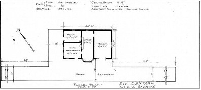
The Oakland depot, according to the 1915 floor plan, was a frame combination station built in 1908. That date matters. Oakland did not receive its actual depot building until six years after the east–west line arrived. Like many early stops, it had service before it had a formal station house. That in itself is revealing. The Frisco deemed the location important enough for passenger and freight handling, but not important enough at first, for one of its standard wooden depots. When the building finally came, it was modest but well-designed. The blueprint identifies it as standard frame construction set on pile-head foundations with two-by-six walls. It had a hip-shingle roof pitched one-third, pine flooring, interior finish of narrow-joint ceiling boards, and exterior one-by-six cove-drop siding. Heating was by stoves, lighting by lamps, and sanitary facilities were provided by outside toilets.
Its dimensions were about forty feet by twenty-four feet. Within that compact footprint, the railroad arranged the essential functions of a small country combination station. There was an office of roughly nine feet six inches by twenty-six feet, where the station agent worked the telegraph, sold tickets, handled freight paperwork, kept records, and served as the railroad’s human face in the town. There was a freight room of about sixteen by twenty-three feet, large enough to hold the crates, sacks, express packages, and incidental cargo of a smaller station. There were separate waiting rooms, labeled on the original blueprint according to the ugly racial divisions of the era, one for white passengers and one for Black passengers. The plan itself, like so much architecture of the Jim Crow age, silently records the social order of its day. Outside the building, theplatformstretched,where trunks, parcels, cream cans, cotton samples, and passengers all passed through the line's daily business.
No confirmed photograph of the actual Oakland depot has been found, but there were sister depots built from the same or nearly identical Frisco plan, with minor dimensional changes. The best photographic stand-in is the depot at Avoca, Arkansas. It was slightly smaller—by about three and a half feet in length and width—but otherwise essentially the same design. Similar depots also stood at Arkinda and Arden, Arkansas. This is important because it allows the lost or transformed Oakland station to be visualized with considerable confidence. The building was not grand, but it was handsome in the plain, workmanlike way of Frisco country depots. It was a building of sheltering eaves, practical proportions, and quiet order.
And from that depot, Oakland’s people boarded the Dinky, picked up freight, received mail, and remained connected to the world that had once passed them by.
The most remarkable thing about the Oakland depot, however, is not merely howitservedtherailroad,but how it outlived it. After the line’s importance waned and rail service ended, the depot did not simply rot beside the right-of-way or vanish into a heap of lumber. It was incorporated into a home and lived on for years after railroading ceased to define the place. That matters. The building was too well-made and too useful to be discarded. Its timbers, walls, roofline, and internal spaces found a second life in domestic use. In that way, the depot followed the same pattern as many frontier structures: first public, then private; first part of atransportationsystem,then part of the intimate life of a household. It survived not as a dead relic, but as an inhabited structure. That afterlife gives the Oakland depot a poignancy the larger vanished stations do not possess. Even when the trains were gone, the building remained in service. It carried on, altered but not erased.
The Aylesworth depot, by contrast, spoke of a town born in the railroad age and intended from the outset to handle more business. Its blueprint, also dated June 1915 but indicating original erection in 1902, shows a larger frame station— about sixty feet two inches in length. It too stood on pile-head foundations with two-by-six walls. It had a gable-shingle roof pitched one-third, pine flooring, lamps for light, stoves for heat, and outside toilets. But the exterior finish differed fromOakland’s.Aylesworth’s used board-and-batten siding, giving the building a somewhat different appearance and texture. The ceiling height—around twelve feet, thirteen feet in places—gave it a more spacious interior feel. And the internal arrangement reveals its role as a much more substantial agricultural shipping point.
Its freight room measured approximately twenty-seven feet four inches by nineteen feet—significantly larger than Oakland’s. That alone tells the tale. Aylesworth needed room for goods because goods defined it. There was an office of about eleven by twenty-three feet two inches, a record room, a counter space, and two waiting rooms, again racially divided according to the practices of the day, each about nine feet four inches by nineteen feet six inches. The platform stretched beside it, allowing freight to be handled in quantity. This was not a token station. It was a true working depot, designed for a producing district whose output justified a sizable freight room and regular traffic.
The architecture of the Aylesworth depot reflected exactly what Aylesworth was. The town was not old and slowly adapted to the railroad. It was railroadmade. Its depot was larger because the railroad expected more from the country around it. Cotton wagons and freight traffic justified that scale. And for years, the building stood at the center of the town’s life. One can easily imagine it in season: cotton wagons lined up, men waiting on the platform, the agent moving between office and freight room, telegraph sounder clicking in the background, the smell of dust, lamp oil, and cotton lint in the air.
Around that depot rose the town itself. At its height Aylesworth had perhaps two to three hundred residents, substantial enough in that country to feel like a true little city. The Washita Valley east of town was famously rich. Over eleven hundred bales of cotton might pass through in a typical year. Corn moved out in carloads. Hogs were shipped in quantity. Cattle from the western prairie camethroughaswell.Ranchers such as N. H. Simmons and the Camden Brothers added to the livestock trade. The First National Bank of Aylesworth, chartered April 25, 1913, under James N. King, gave local commerce a financial base. General stores, lumber yards, a cotton gin, a blacksmith shop, a hotel, physicians, a church, and a school all anchored the community. Therailroadbrought goods, customers, supplies, and the daily business that made the town viable.
Aylesworth also housed one of the more unusual institutions in the county—the Aylesworth Prison Farm, where African American inmates worked cotton, corn, and vegetables, and raised livestock, all under state supervision. It reflected the penal philosophy of its time, harsh and paternalistic, but it also reflected how deeply agriculture structured the town’s identity.
And through this whole railroad world moved the little train that older Marshall County residents remembered with such affection: the Dinky.
Officially, the Frisco called these branch-line motorcars “Doodlebugs.” Locally, many called them the Dinky. The name itself carried affection. If a person today remembers riding the Dinky in Marshall County, that person is likely well along in years, because the train belonged to a world now long gone. The Frisco introduced these gas-electric motorcars beginning in 1910, ordering ten at first and then adding more in 1913. By 1914, the company had twenty such units, and by 1931 it operated a larger fleet that included gas-electric motorcars, gas-engine motorcars, trailer coaches, and baggage-mail units. These cars were about 72 feet long and had a 400-horsepower engine. They combined passenger space with baggage or mail compartments, making them ideal for lower-volume branch-line service.
In Marshall County, the Dinky passed through Madill and Aylesworth twice a day. It left Ardmore early in the morning, moved east through Madill and Aylesworth toward Hugo, and later returned westward, making a full round trip of roughly eight and a half hours. In Hugo, a traveler could connect to another motorcar and continue on to Hope, Arkansas. The Dinky carried passengers, mail, express packages, and light freight. In places like Madill and Aylesworth, it was the principal means by which incoming mail arrived and outgoing mail departed. It was not glamorous. It was useful. That usefulness is precisely why people loved it.
The Dinky was a big thing along this line because it fit the country. It was not too large for the towns or too formal for their needs. Children knew its sound before they knew much else about trains. Farmers listened for it across the fields. Merchants depended on it without ceremony. Older people remembered riding with windows down, hair blown by the wind, watching the countryside slip past in a way that made even a short trip feel like an adventure. In the years when highways were poor, automobiles were fewer, and buses were not yet dominant, the Dinky was not quaint. It was practical lifeblood.
In the late 1930s, as the building of Lake Texoma began tothreatenoldroutesand older towns, the Dinky’s path shifted, and it ran through Kingston on its way toward Durant. This was the period when the train stood most vividly in popular memory. People could ride from Madill or Kingston down to Durant for a day of shopping or business and return late in the afternoon. The Dinky was part of ordinary life. By the 1950s, however, buses and automobiles had begun to supplant it. It also suffered from lateness. It could run an hour or more behind schedule, and that uncertainty made it less useful. The last Dinky on the Frisco was Number 2128 on the Ardmore–Hugo line, and its final run came on November7,1953.Withthat, the motorcar service that had so long stitched small towns togetherpassedintomemory.
Meanwhile, the Arkinda– Ardmore line itself matured into a fully working freight corridor. Beyond Marshall County, it served a wide range of businesses. There were paper mills at Ashdown and Valliant, a cement plant at Foreman, later a coalpowered generating plant at Fort Towson, pulpwood loading points, and many local industries. The line interchanged traffic with the Missouri Pacific and Louisiana & Arkansas at Hope, with the Kansas City Southern at Ashdown, with other carriers at Valliant, with the Katy and other roads at Durant, and with the Santa Fe at Ardmore. Hugo became the crew-change point and operating hub. Because of the grades north of Hugo toward Fort Smith, traffic involving the Campbell Soup plant at Paris,Texas,andothermovements often ran through Madill ratherthanoverthemore difficult northern routes. As a result, the line between Hugo and Madill was especially important.
The west end of the line near Ardmore carried its own complications. There werelong-standingquestions about the precise relationship between Frisco trackage and the Rock Island lines near Frisco Junction and Ardmore. Later records and recollections suggest that the Frisco may initially have used trackage rights over a line originally tied to the Western Oklahoma Railroad and later absorbed into the Rock Island system, and that over time the Frisco acquired fuller rights and eventually outright ownership interests as those lines were leased, abandoned, or sold. Some records suggest an original Frisco-built line toward Ardmore that was later removed; others suggest joint use from an early date. However tangled the details, the practical result was clear enough: by the 1920s and 1930s, Frisco Junction appeared on Frisco passenger schedules, and Ardmore remained an important western anchor of the line, tied into Santa Fe connections and regional commerce.
Then came the final transformation, and this one was larger than the railroad.
The construction of Denison Dam and the creation of Lake Texoma required the abandonment of about 16.6 miles of the Ardmore Subdivision between Mead and Madill in 1942. The Frisco built new trackage from Mead to a connection on the Sherman Subdivision at Lakeside, Oklahoma, and Ardmore Subdivision crews thereafter used that route to reach Madill. This replacement trackage became one of the early segments on the Frisco to use centralized traffic control, with the operator at Madill controlling the panel. Even in the face of loss, the railroad adapted.
But adaptation did not save Aylesworth.
Aylesworth lay within the territory to be inundated. Surveyors came. Appraisers came. Compensation was offered,butformanyOklahoma landownersitwasbitterly insufficient, especially when compared with valuations on the Texas side. Families left. Houses were moved if possible. Others were abandoned. Businesses closed. Churches held final services. Schools held final commencements. By1944,thedepot,thestores, the homes, the prison farm, the fields, and the streets of AylesworthlaybeneathLake Texoma.
The contrast with Oakland is striking and worth dwelling on. Oakland, older than the railroad, survived the railroad’s disappointments and even saw its depot live on after the line’s abandonment by becoming part of a home. Aylesworth, by contrast, was born of the railroad and died with the drowning of the country that sustained it. Oakland’s depot had an afterlife. Aylesworth’s did not. Oakland bent and continued. Aylesworth was erased.
And that, in the end, is why the Arkinda–Ardmore line must be understood as more than a route on a map or a technical railroad subdivision. It was a force that touched every layer of life in Marshall County. It arrived in a region that already had an older center in Oakland. It reinforced the rise of Madill. It created Aylesworth as a depot town for the Washita Valley. It tied local farmers and ranchers to eastern and western markets. It provided the county with passenger, freight, and mail service, and a connection to a wider world. It brought with it little country depots built from standardized plans, structures humble in appearance but immense in importance. It gave people the Dinky, that small train with a large place in memory. And in the end, it became one more thing overtaken by a newer age of engineering when the dam came, and the waters rose.
Still, the line is not truly gone. It lingers where iron once ruled, not as steel, but as something deeper—something pressed into the land and into the memory of those who lived along it. It persists in the towns that remain, where streets still follow the logic first imposed by the rails, and in the ghostly outlines of those that do not, theirnamesspokennowmore often in remembrance than in conversation. It endured in the weathered timbers of theoldOaklanddepot—those boards that once heard the hiss of steam and the shuffle of freight, and which, even after the trains fell silent, refused to die with the railroad, instead took on a second life as part of a home, sheltering families beneath a roof first raised for commerce and passage. It survives in the remembered presence of the Madill Union Depot, where the rhythm of arrivals and departures once set the tempo of an entire town, and in the careful, deliberate lines of the Aylesworth station blueprints, where a larger vision had been drawninink—waitingrooms measured for comfort, freight doors built for labor, and an agent’s window placed where news and goods would pass hand to hand.
It lives on, too, in the small things—the things no survey ever recorded and no blueprint could capture. In the weight of cotton bales stacked along the edge of a platform, their fibers catching the Oklahoma sun. In the sound of boots on worn planks, in the low murmur of neighbors gathered not just for business, but for the simple act of being together. In the quiet exchange of mail and word through the agency window, where news of the wider world arrived in envelopes and folded pages. And in the memory of motion itself—in the recollection of those who still remember riding the Dinky through Marshall County,thecountryside slipping past in a steady, unhurried procession, each mile a thread binding one small place to another.
But more enduring than timber, more lasting than paper, is what the railroad left behind in the earth itself.
The rails are gone. The ties are gone. The ballast has long since settled and scattered. And yet the roadbed remains.
From Ardmore eastward, across open pasture and through quiet timber, all the way to the waters of Lake Texoma where Aylesworth now lies beneath the surface, the old Arkinda–Ardmore line still reveals itself—not boldly, but faithfully—to those who know where to look. It is there in the long, unnatural straightaways that cut across land which otherwise bends and yields to creek and contour. It is there in the slight rise of ground where no natural ridge should be, in the subtle embankments that lift the earth just enough to carry what once was steel and motion and purpose. It is there, faint but certain, a line drawn not in ink, but in soil.
South of Kingston, where the north–south line once ran through Woodville before it too was surrendered to the lake, that same imprint lingers. The water may have taken the track, the towns, and the daily life that once gathered there, but it did not take the mark left behind. Along the margins of that drowned corridor, the land still remembers. The grade can still be traced. The path still holds.
These are not temporary marks. They are not the kind that weather washes away, or grass fully conceals. They are the result of deliberate shaping—ofmenwhocutinto hills, who filled low ground, who forced a straight line across a country that was never meant to be straight. The railroad did not simply pass through this place. It imposed itself upon it. It carved, it raised, it pressed, and in doing so, it left behind something that endures long after the purpose for which it was built has faded.
These scars are permanent.
They are quiet now, softened by time, covered in places by pasture or brush, interrupted by water and distance—but they remain. They are the earth’s own memory, a record that does not rely on paper or testimony. Theydonotspeak,and yet they tell the whole story to anyone willing to see it.
And so the line lives on— notonlyinwoodandmemory, not only in blueprints and recollection, but in the very ground beneath our feet. The trains are gone. The whistles are silent. The depots have fallen or been repurposed. The towns have changed, or vanished altogether. But the path remains—faint, enduring, undeniable.
A scar across the land. A reminder of what once was.
And proof that some things, once laid down with purpose, are never truly erased.
That is the story of the Arkinda–Ardmore line in Marshall County. It is not only a story of trains. It is a story of foundations and freight rooms, of cotton bales and telegraph keys, of towns made and towns displaced, of buildings that lived twice, and of a little motorcar that doodled down the line while the country watched it pass. It is a story of the county as the railroad remade it, and of the strange truth that even after steel is lifted and water covers the ground, the old line still runs—if only in memory.
Next week in Part VI, Madill gets a grand new station.