

Before the depot stood at Woodville, before the Frisco timetable ruled the movement of freight and passengers, before the whistle echoed across the bottoms of theWashitaandtheRed,that country belonged to another order of travel. It belonged to ferrymen and waggoners, to muddy approaches and river landings, to hand-drawn crossings and long hauls from Texas. It belonged to a frontier economy in which distance was not measured merely in miles, but in floodwater, mud, current, and delay. The old Woodville country did not face south toward the railroad at first. It faced south toward the river, toward Thompson’s Ferry, toward Denison, and toward the uncertain crossings that made trade possible long before steel rails and telegraph wires stitched this country into something modern. Then the iron road came, and as railroads so often did, it did not simply pass through. It rearranged the whole world around it. It shifted commerce, pulled towns from their old foundations, dimmed the old ferry crossings, and left behind a landscape where even survival required movement.
By the time the Frisco pushed south out of Helen— soon to be Kingston—it was entering one of the loneliest and most river-bound corners of what would become Marshall County. The rails had not yet conquered that country. Roads were primitive, distances were measured more in hardship than in miles, and the lifeline of trade ran not on iron, but over water. Before the coming of the railroad, the settlement that would become Woodville sat in deep dependence on the Red River corridor. As the crow flies, Oakland lay roughly fifteen miles to the northwest, but it was small and limited. Denison, some twelve miles to the southeast, was the true commercial magnet. From Denison came dry goods, hardware, foodstuffs, tools, lumber, and the other necessities of frontier life. Those commodities did not arrive easily because the mighty Red River stood between the two towns. Goods came by wagon, creaking northward out of Texas, and crossed the Red River on ferries such as Thompson’s Ferry, located due south of the pre-railroad site of Woodville. Before the whistle of the locomotive echoed through that country, the ferryman was as important to the life of the settlement as the merchant, the blacksmith, or the preacher.
AndtounderstandHarney and early Woodville, one has to understand the ferry business in fuller measure, because the ferries were the true southern gates of the county before the railroad. They were not picturesque curiosities. They were the essential infrastructure of an earlier age. They carried not just people, but the daily material of life itself: lumber for houses, nails for barns, flour, sugar, coffee, and salt for family tables, dry goods for store shelves, plows, harnesses, and wagon parts for the fields, as well as mail sacks, newspapers, travelers, livestock, produce, and cotton. Before a bridge could command a river, and before a railroad could cross it in permanent triumph, the ferry was the hinge on which all of that movement turned.
For the Woodville country, Thompson’s Ferry was one of the most important of those hinges. Later accounts remembered that in the latter part of the 1860s, James Petty “J. P.” Thompson—“Uncle Jim” to those who knew him—established a ferry near the point where a steel bridge would one day span the Red River. From then on, the place bore his name. Thompson’s Ferry became the main threshold between Denison and the settlements to the north, and so long as Woodville remained off the rail line, that crossing was one of the community’s lifelines. If Denison was the supply house, Thompson’s Ferry was the doorway. It turned distance into commerce.
Nor was that system confined to the Red River alone. The Washita, too, demanded crossings, and men like William R. Watkins operated ferries there. In the country near the junction of the Washita and Red, ferries formed a network of passage. They joined Texas markets to Chickasaw farms, river bottoms to uplands, remote settlements to post offices, and frontier isolation to the larger world. A reliable ferry could make the prosperity of a neighborhood just as surely as the loss of one could weaken it.
The newspaper record, looking back from a later age, preserves the flavor of thatvanishedworld.AMarch 14, 1918, article in the Daily Ardmoreiterememberedthat “years ago a settlement a short distance from Thompson’s ferry, on Red River, and just a few miles above the mouth of the Washita, was christened Woodville, and was for a long time and until the Frisco railroad came through, a post office and trading point for the settlers of that section.” That sentence says almost everything. Before the railroad, Woodville existed where it did because the ferry and the rivers made it useful. The same article recalled that in thesummerof1900,thetown was moved from the old site to the new one and began again along the railroad. It then turned to the country itself, praising the Woodville section as one of the best farming districts in the county, especially adapted to corn and cotton. The bottom landsoftheRedandWashita, it said, were “as fertile as any in the world.” Alfalfa grew there to perfection, fruit and vegetables thrived, and M. U. Ayres maintained a ten-acre Elberta orchard so large that by 1916, fruit was being shipped from it in carloads. High-quality cotton came from the district, and seed breeders such as R. A. Owen had built reputations in both Oklahoma and Texas for pure-bred corn, supplying state and federal demonstration agents and boys’ clubs. The article was written in a booster tone, to be sure, but the point stands firm: this was rich country, and rich country sooner or later demands better transportation than wagons and ferries alone can give.
Another retrospective, published in the Red River Farmer on August 19, 1920, reached further back still and painted the old life in broader strokes. It described Woodville as “nestled in the valleys of the famous Washita and Red Rivers,” on the southern edge of Oklahoma, with Texas only a few miles away, and said that the old trading post known as Old Woodville had been established “sometime in the sixties.” Whether that date reflects local memory more than exact postal chronology, it captures how the community saw itself: old, river-born, and deeply rooted in an era before the railroad. That article recalled a time when mail was moved by stage line, and freight was hauled by wagon, sometimes byoxteamsandsometimesby horses or mules, from points as far away as Jefferson, Texas. It remembered provisions and supplies coming by river boat as far inland as navigation would permit and then being carried onward by land. It even said that on occasion, a trading trip might be made to Leavenworth, Kansas. Mail, it added, was hauled overland from Pottsboro in the early 1880s by J. H. Beene, and the round trip often took several days, depending on the river. There is the old frontier in miniature: nothing quick, little certain, everything dependent on weather, road, and water.
That same 1920 piece also described the hard edge of those times. There was, it said, little law and order, and every man was largely sufficient unto himself. If lawbreakers were caught, they were taken to Fort Smith, where federal justice awaited. But the article also remembered the country’s abundance: wild fruit, plentiful game, fish in nearly every stream, and even beavers building dams down toward the mouth of the Washita. Around that same early era, the paper said, a man named Wood established a trading depot near the site of Old Woodville and a United States post office was established there. Whatever compression of dates and origins may exist in that recollection, the larger truth is plainenough.Longbeforethe Frisco, the Woodville country was already a place of trade, traffic, and promise, tied to the ferries and to the Red River road south into Texas.
The story of Woodville is, in truth, a story of movement. It is one of those frontier tales that can make a map look like a living thing, because the town itself did not stay put. It shifted, retreated, reformed, and finally hitched its future to the steel road. Whatlatergenerationscalled “Old Woodville” was not the oldest Woodville at all. It was the first new Woodville, the town that moved to meet the railroadin1900.Bythatmeasure, the latter community called New Woodville was really “New New Woodville.” It sounds almost comic at first hearing, but it tells a hard fact about settlement in Indian Territory: towns that wished to live often had to move.
The place began not as Woodville, but as Harney, Indian Territory, established on November 8, 1881. That made it the second town founded in what is now Marshall County, the first being Oakland on July 20 of the same year. In that era, a town’s real birth certificate was often its United States post office. Before telephones, before paved roads, before modern transportation, the post office stood as both a communication hub and a federal acknowledgment. A place with a post office was no longer just a cluster of houses or a local neighborhood. It had a recognized name, a place in the wider world, and some claim to permanence. That is why so many Indian Territory communities date themselves from the establishment of the postal service, and why namessooftenchangedwhen the Post Office Department refused duplicates. Helen became Kingston for that very reason. Another Helena already existed, and the federal governmentwouldnotpermit confusion. So, one town lost its name, and another took it.
Harney had its own distinct origin. It was first located on the Red River about a mile and a half west of what latercametobeknownasOld Woodville.Itwasnamedafter Sison Harney, a full-blood Chickasaw woman whose life bridged the old world of removal and the new world of allotment, territorial law, and statehood-era litigation. Her roots ran deep into the earliest Chickasaw history of the region. Her father, Luppahubby—also recorded as La-Pa-Hubby and Lupphubbia— and her mother, Ah-Co-Na-He, came west from the Chickasaw homeland in Mississippi during the forced removal era. By the 1830s, they had settled in the Brownsville area of what is now Marshall County, much of which now lies beneath Lake Texoma. There, sometimearound1840,Sison was born. A younger brother, Chikiee, also called Loman, followed about a decade later. Precise dates are elusive, as they so often are in frontier and tribal records, but the outlines are clear enough: Sison Harney belonged to the generation born in the wake of removal, raised in a country that was still being remade by exile, adaptation, and survival.
At some point, the family adopted the surname Brown, but Sison is remembered as Harney because of her marriage to Wesley Harney, a part-Chickasaw man who was nevertheless a citizen of the tribe and a figure of consequence in Chickasaw public life. He served on the Chickasaw Supreme Court and in the legislature and, by all accounts, was widely respected.HeandSisonmade their home along the Red River near the country of her birth. They had no children, yet their names became attached to the settlement that grew up nearby. That, too, says something about the frontier. Not every town was named for a military man, railroad official, or land promoter. Some bore the names of those who had simply been therelongest,hadstandingin the community, and lent the place their identity.
Wesley Harney died on September 11, 1893, while traveling to Tishomingo for a legislative proceeding. The cause was not recorded clearly, but his death was treated with solemnity. Three days later, the Chickasaw Legislature convened, observed a period of silence in his honor, and adjourned. He was buried at Isom Springs Cemetery. Sison outlived him by decades. In 1902, she and G. W. Vaughn obtained a marriage license at the federal courthouse in Ardmore, though the marriage apparently never took place. In 1903, she received an eighty-acre allotment in the Isom Springs area and thereafter lived on that land. In later years, she ceased to be known formally as Mrs. Sison Harney and became instead “Grandma Harney,” which may be the most revealing title of all. She had no children and no grandchildren, yet the people of the community claimed her in that intimate way. Her death notice used that name. To the countryside, she was grandmother in affection, memory, and local esteem, if not by blood.
She died on May 29, 1930, and even then, the record carried contradictions—a newspaper notice placing her death at home, court papers saying Durant hospital, probate documents estimating her age differently than the press. Such inconsistencies are common in old records, but one thing is certain: her story did not end in the grave. Her estate sparked a will contest important enoughtobecomeapublished Oklahoma Supreme Court opinion on testamentary capacity. In that sense, Sison Harney lived on twice—once in the name first given to the town, and again in the legal memory of the state.
Yet Harney itself was never fixed. Sometime between 1881 and 1888, the Red River flooded the basin, devastating the first site. The town then shifted a few hundred yards north to higher ground and re-established itself. So even before it became Woodville, it had already moved. River country could be rich, but it was never gentle. The same waterway that carried commerce could also erase improvements overnight.
Despite its isolation, Harney developed the usual frontier institutions. The first store was opened in 1884 by a mysterious figure known only as Kid Morton. No one, it seems, remembered or recorded his given name. That store later passed to Jim Moyer, who had come to Harney soon after the town’s founding and had first made his living as its schoolteacher. He farmed, saved, and eventually bought the business. Moyer expanded it aggressively, putting about $3,000 into stock—a substantial investmentforthetime—and trading in cotton, produce, and nearly anything else that could be bought or sold. He became one of those frontier merchants who functioned as banker, broker, buyer, and supplier all at once. But the border country was violent. On December 23, 1888, Moyer was murdered by a man known only as Luttrell, who escaped and was never caught. After Moyer’s death, the business passed to J. L. Coffee and William Thomas Christian, names that would remain tied to the area’s history. Coffee later operated a dry goods store after the town relocated,andChristianwent on to serve first as constable of Woodville and later as sheriff of Marshall County.
Harney also had a cotton gin by 1885, built by two Dutchmen remembered only as Fred and Louis, and that same year saw the opening of its first blacksmith shop. These fragments matter because they show what the place had become before the rails arrived. This was not merely an isolated river settlement of cabins and subsistence farmers. It had enough cotton production to justify ginning, enough commerce to support stores, and enough movement of men, horses, wagons, and tools to require a smithy. It was alive. But it was alive by wagonroad standards, not railroad standards.
Its closeness to Denison and the river crossings brought with it a rougher underside.Moonshineflowed freely, according to later recollections, and federal marshals spent much time in the area battling bootlegging. Murders stained the region. One feud reportedly claimed six or seven lives. That violence was not accidental. Harney lay in the old border country where river crossings, jurisdictional confusion, remoteness, and trade routes often bred lawlessness. Ferries were not merely a commercial infrastructure. They were chokepoints of travel and escape, places where lawful commerce, illicit traffic, gossip, and danger all mingled.
And the Thompson family remained woven deeply into that history. Thompson was born on November 26, 1850, at Preston Bend, Texas, just across the Red River from whatwouldbecomeMarshall County. A 1912 piece in The Madill Times, published whenThompson’sson,Harry M.Thompson,announcedfor county commissioner, casts useful light on his father, J. P. Thompson. Harry, the paper said, was born in Texas in 1882, “just across Red River from Woodville in Preston Bend.” It then stated that his father, J. P. Thompson, moved to this side of the river in1888,whenHarrywasonly six years old, and that the boy was raised on his father’s farm and ranch. That one statement matters greatly. It places J. P. Thompson not merely as the namesake of an old ferry crossing, but as one of the substantial men who came into the Woodville country in the very years when Harney had become Woodville and the river-ferry economy was still dominant.
J.P.’s first wife was Maggie Massey. They were married in 1877. In 1880, the couple welcomed their first child, Myrtle. Then, in 1882, Harry was born. Sadly, just a few months after Harry was born, Maggie died. J.P. raised his two kids alone for about three years before marrying Lucy Harney, better known as Lucy Juzan. Readers of this column will remember that Lucy was a member of the well-known Juzan family and a sister of Alex Juzan. Her first husband, Eastman Harney, drowned in an accident on the Washita River. After the death of Eastman, Lucy married Almarine Watkins. He was later murdered byJamesWasson,thesubject of my previous series entitled “No Man’s Law.” After Watkins’ murder, she married Thompson. After he married Lucy Juzan, Thompson was granted citizenship in the Chickasaw Nation by intermarriage.
The renaming of Harney to Woodville on July 9, 1888, brought the town into the orbit of one of the most remarkable men in southern Chickasaw Nation history: Judge Laban Lipscomb Wood.BorninHalifax, Virginia, on January 1, 1849, Wood came of age in a world shattered by war. His father died when he was a child. His family moved to North Carolina after his mother remarried. One brother fought for the Confederacy and rose to major. L. L. himself later served in the United States Army from 1867 to 1870 and ended that service with the rank of colonel. Somewhere along the way he lost an arm, a wound that became part of his frontier legend.
Around 1870 he moved to Preston Bend, Texas, that great elbow of country near themouthoftheWashitaand the Red River. From there he crossed into the Chickasaw Nation in 1871 under the tribal permit system that allowed white men to work for Chickasaw citizens. The treaty background to that world mattered. The Choctaw and Chickasaw Nations had been forced west, their political geography redrawn by federal treaties, and non-Indians were not supposed to live or labor in the Nation without permission. Unauthorized whites were “intruders,” later derided as “boomers.” The permit system was a compromise with economic reality. It recognized that ranching, farming, trade, and development had drawn more outsiders into the Nation, even as the Chickasawstriedtomaintain legal control.
Wood’s permit came throughWilliamR.andBetty Watkins, who held substantial land near the junction of the Washita and Red Rivers and operated a ferry across the Washita. That one detail alone places Wood squarely in the river-crossing economy that shaped the region before the railroad. He was not merely a lawyer or judge transplanted into the territory; he was a man whose fortunes were rooted in the practical world of ferries, farms, timber, cotton, and river traffic.
While in that country he met Francis Ellen Burney, daughter of Emily Love and Judge David Burney, and connected by family ties to some of the leading Chickasaw figures of the age, including Governor Benjamin Franklin Overton. Through marriage Wood became deeply enmeshed in Chickasaw leadership circles. Governor Overton later appointed him probate judge for Pickens County at Oakland in 1876. Wood also served as auditor for the Nation and as a trusted advisor to the governor.
His life in the Nation was anything but quiet. In 1877, while riding with Governor Overton, he became embroiled in a violent encounter with a man named Meeks after Wood shot an attacking dog. Meeks responded with a shotgun blast that riddled the governor’s coat and shirt with buckshot. The two men escaped, and the episode hardenedOverton’slanguage against the white intruders he wanted removed from the Nation. Later that same year Wood traveled as part of a Chickasaw delegation to Washington, a sign of the standing he had achieved.
In October 1878 Wood traded for the Watkins farm west of the Washita’s mouth, on the site later associated with Old Woodville. There he built up a formidable operation— wood mills, a cotton gin, and over 1,600 acres of cotton under cultivation. At one point he even owned the Denison Democrat. In that fact alone one can see the arc of the region before the rails: Denison mattered immensely to the country north of Red River, and a man who controlled timber, cotton, river-adjacent land, and a Texas newspaper was not a minor figure.
Then came the violent end. On October 2, 1882, while hosting a dinner for employees of one of his mills, Wood rebuked a worker named Slaughter for vulgar language at the table. Slaughter left, returned with a firearm, and shot Wood in the shoulder and chest. Mortally wounded, Wood nonetheless drew his own pistol and, bracing himself on the stump of his lost arm, shot Slaughter twice in the abdomen, killing him. Wood died only hours later, at age thirty-three. It was the kind of death frontier memory never forgets—savage, sudden, and dramatic enough to harden into legend. Six years later Harney took his name. Therenamingwasmorethan flattery. It was a local act of memorialization, tying the town to a man whose influence over the district had been deep and whose death had become part of its lore.
But if Woodville gained a powerful name in 1888, it still lacked what the coming century would demand: a railroad connection. That was the great turning point. When the St. Louis-San Francisco Railway, the Frisco, began extending south from Sapulpa toward Texas in 1900, it remade the geography of the territory in the old, ruthless way railroads always did. Towns fortunate enough to lie on the line prospered. Towns left off the line withered, moved, or died. Oakland learned that lesson. The original Kingston learned it. Woodville learned it too.
The railroad’s southward push after Kingston carried it near the existing Woodville settlement, then onward toward the Washita River, across to Platter, and from there to the Red River crossing on the way into Denison, Texas. This route effectively stitched the old river-dependent world into a new iron network. The Washita and Red River crossings had long controlled movement. Now the railroad would dominate both, reducing old wagonand- ferrydependencyevenas it depended, at first, on the same geography those ferries had long exploited.
Woodville’s answer to being bypassedwasnotresignation, but relocation. In 1900 the town moved again—this time not because of floodwater, but because of steel rails. What had been Harney, then Woodville, then a second site after flooding, now shifted bodily to the Frisco line. The town commissioned Alfred B. Beard to lay out and plat the new site. Beard was no amateur surveyor. He had previously laid out towns such as Ravia and Sapulpa and was involved in planning the railroad route from Sapulpa south to the Red River. Once the new plat was established, buildings, barns, and houses were moved by horse-drawn trailers. The old town physically hauled itself toward its future. That image ought to stop a reader cold: not a new town springing up from scratch beside the rails, but an old one wrenching itself loose from the river road and dragging its entire life to the tracks.
That is why the place later remembered as Old Woodville was really the first New Woodville. And that is why the later community called New Woodville is, in strict historical logic, “New NewWoodville.”Strangeasit sounds, the phrase captures the town’s layered geography better than any neat modern label could.
If one wants to know what Woodville became after it moved to the Frisco, a vivid answer survives in a long newspaper sketch published in The Madill Times in January 1911 under the title “Woodville,HerSurrounding Country and People.” That article captured the town at a moment when the old river settlement had already remade itself into a thriving railroad community and whenlocalpridewasrunning high. Woodville, the paper declared, was the second town on the Frisco south of Madill, sixteen miles away and only about three miles north of Red River. The Washita, it noted, flowed into the Red some four to five milessouthofWoodville,thus giving the town the benefit of two rich river bottoms from which to draw trade. The writer was not engaging in empty boosterism when he praised the surrounding country. He described those Red and Washita bottoms as among the finest lands in Oklahoma, especially suited to corn and cotton, and said the country could produce fifty to seventy-five bushels of corn to the acre or a bale of cotton, with a sandy loam soil that was both easily cultivated and agreeable to work. Woodville’s prosperity, in other words, was not accidental. It stood where transportation, rich bottom land, and a trading history all came together.
Thesamearticledescribed the town’s move to the railroad not simply as a new town being laid out near an old one, but as the people of Woodville uprooting the town and shifting it onto the rails. Woodville did not die when the railroad bypassed its older location. It dragged itself to the line. The article said the pioneers of old Woodville werethenjoinedbysome from Texas and elsewhere, and that together they soon built “a splendid little town.” In that one passage lies the whole logic of railroad-era survival on the frontier. The town did not wait for fortune to find it. It moved to meet fortune where the tracks lay.
By 1911, the long Woodville feature in The Madill Times listed J. P. Thompson among the principal landowners and prosperous farmers of the district, alongside namessuchasWilliamVann, Jim Vann, D. W. Vann, T. J. Coffee, R. A. Owen, J. J. Lynch, Thomas Juzan, E. H. McDuffee, and Mrs. Steel. The paper remarked that these were citizens of the Choctaw or Chickasaw Nations, except for R. A. Owen, who had purchased his land, and that thousands of acres of excellent land lay within Woodville’s trade territory, with many farmers bringing their crops there to market. This is a rich passage for the history of the town because it shows how deeply the community remained rooted in the older landholding world of the Nations, even as the railroad economy reshaped it. In that list, the Thompson name appears exactly where one would expect it: at the intersection of the old river world and the newer railroad farm market.
The business portrait in that 1911 newspaper reads almost like a walking tour through the new town. On the north side of the street were Shaw & Sons, carrying dry goods and clothing under themanagementofMrs.J.K. Warren, a concern the paper said had been there for years and enjoyed a good trade. Nearby stood John Taylor, selling general merchandise. Taylorwasdescribedasoneof the men who had come from the old town and had been trading there seven years before New Woodville was established. Though he had beenburnedoutonceandsuffered other setbacks, he was still doing well, carrying “a splendid line of nearly everything you need” and waiting on customers early and late six days a week. Across the street, J. F. Ringle, who had come from Isom Springs only about a year earlier, sold dry goods, groceries, and cold drinks in season, and was said to be pleased with both the school and the town.
There was J. M. Steel, the meat market man, who also carried a small line of groceries. Raised just across the river on the Texas side, Steel had come to Woodville soon after the railroad, in 1903, and for five years had been cutting meat for the people there. He had lately added groceries, the paper observed, as evidence of how hewas“gettingalong.”Onthe south side of the street stood W. T. Wiley, doing a flourishing businessinhardwareand implements. Wiley had come from Tishomingo in 1905 and opened up when he was not worth much money, but by 1911 had plainly prospered. The article remarked that he enjoyed the confidence and tradeofmanypeopleandthat such confidence was what made living worthwhile for the man and his family.
Then came the banks and larger mercantile establishments, themarksofatownno longer merely surviving but taking on permanence. The First National Bank stood in line with R. A. Owen as president and M. U. Ayres as cashier. The Bank of Woodville had been organized in 1900 and in 1905 reorganized as a National Bank, with Owen elected president in 1907. The writer praised Ayres as an efficient cashier and one of the most highly esteemed young men in the community. Nearby was the grocery concern of J. Hamp Willis, with J. O. Summit in charge, described as a continuation of the old Owen-Willis-Wheeler Mercantile Company, carrying dry goods, clothing, hats, shoes, and a full line of groceries. On the same side, S. R. Owen was selling groceries and dry goods for R. A. Owen, and the writer, admiring the stock and the business sense behindit,remarkedthatSam knew how to please customers and had won them.
The article continued on with H. H. Delay, who kept groceries, confectioneries, and cigars and was also constable of the justice precinct; with W. R. Buckley, proprietor of the drug store and post office and postmaster since 1902, described as one of the most pleasant and genial menonemightmeet;withEd McCunn and R. L. as proprietors of a two-chair barber shop on Main Street; with G. W. Bostick, who handled the livery business and had served depot traffic for ten years; and with the “Village Blacksmith,”NarvelLuttrell, whose shop was described as splendidly equipped and who was said to be among the best blacksmiths in that part of the state. The hotel facilities, the paper boasted, were better than those usually found in towns twice Woodville’s size. The Purcell House, operated by W. A. Purcell, was the first house one met coming up from the depot, while the Woodville Hotel was run by Mrs. L. M. Waterson. At either place, the article said, the hungry traveler could get all he wanted to eat and a fine bed in which to rest himself. This was not a mere flag stop on a lonely line. It had become a full little railroad town. That is a telling detail because it shows Woodville not merely as a local farm marketbutasarailroadtown with enough through traffic to support hotels, a livery, depot-facing businesses, and the ordinary services required by travelers.
The civic portrait in the same article is just as telling. Woodville, it said, had four churchorganizations—Methodists, Christians, Presbyterians, and Baptists—though only two church buildings, belonging to the Baptist and Methodist congregations. The writer plainly admired the place and declared that Woodville was “a splendid little town.” He said it had been his happy privilege to live among those people for four years and that he had no better friends anywhere. Evenmorerevealingwerethe figures given for the schools.
Woodville’s school district, according to the county records cited there, was the second-wealthiest school district in the county and second in scholastic population, with 237 scholastics, taxable property valued at $396,496, a $15,000 school building, and a corps of seven teachers, including five literary teachers and two music teachers. Prof. J. B. Steed served as principal, assisted by L. E. Hargrove, Miss Ora Stanford, Miss Van Hoesen, and Mrs. J. B. Steed, with an average attendance of about 150 pupils. Those figures matter because they show how swiftly Woodville had matured after moving to the railroad. Within a decade it was no makeshift siding settlement. It had schools, churches, hotels, banks, merchants, and a trade area rich enough to sustain them.
The same article also names some of the town’s public officials, which helps round out the portrait of Woodville in its early railroad maturity. A. Gresham was the mayor. R. C. Strickland was a justice of the peace. H. B. Moore was the township trustee for Odell Township. The writer praised both Strickland and Moore as excellent men who had held their positions since statehood andhadbeenelectedthe previous year without opposition. Those details may seem small, but they are precisely the sort of facts that reveal a town settling into civic adulthood. The railroad had not simplymovedfreightthrough Woodville; it had helped anchor institutions. They show that within barely a decade of its move to the railroad, Woodville had become a community withbanks,churches, schools, hotels, merchants, public officers, and a vigorous trade territory fed by some of thebestfarmlandinsouthern Oklahoma.
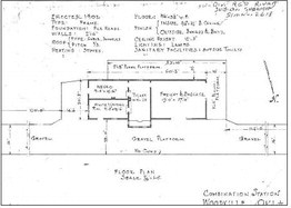
Because the town relocated in 1900, the Frisco depot itself was not erected there until 1902. That detail matters. The rails came first; the full physical expression of the station town followed. The floor plan of the Woodville depot shows a structure that was practical and modest, built for mixed serviceratherthangrandeur. It was a combination station, the sort of building common in secondary-line towns where passenger service, freight handling, ticketing, and telegraph or agent work all had to be folded into one compact frame building. It measured 60 feet 3 inches in length and 20 feet 2 inches in width. A plank platform ran along the south, or “track side,” of the station for 53 feet 10 inches, and extended along the entire west side. A gravel platform bordered the full length of the north and east elevations.
The plan notes that it was a frame structure, erected on pile-head foundations, with 2×6 walls, a gable-shingled roof, and heated by a stove. Lighting was provided by lamps, and the sanitary facilities were not indoors at all, but consisted of outside toilets—a detail that tells the truth plainly about the scale and amenities of a small Indian Territory station in that era.
Inside, the building was arranged with stern economy. There was a segregated waiting arrangement, with one room designated for white passengers and another for negro passengers—a sharp reminder that even in Indian Territory, railroad architecture carried the racial order of its time directly into the floor plan. Interestingly, unlike other depots in the region,thetwowaitingrooms were identical in size, each measuring 14 feet 6 inches by 9 feet 4 inches.
Nearby stood the ticket office, small but central—the nerve point of the building— placed between the waiting area and the freight side so the station agent could oversee both passenger and shipment business. The largest interior space was the freight and baggage room, which is revealing in itself, measuring 27 feet 6 inches by 19 feet.
Woodville was not a stop whose importance lay chiefly in passengers stepping off in fine clothes. Its importance lay in cotton, produce, merchandise, express, trunks, crates, and all the practical burdens of a working countryside. Outside were plank platforms and gravel platforms, extending the usable space and allowing wagons to draw up for loading and unloading. The very proportions of the plan reveal the truth of the place: Woodville was a freight town first and a passengerstopsecond,bound to the region's agricultural and commercial life.
That depot stood as a kind of frontier hinge. Behind it lay the old world of ferries, wagon freighting, remote river settlements, handdrawn crossings, and the long pull to Denison for goods. South of it the line pressed toward the Washita, then to Platter, then over the Red River into Texas. Ahead lay integration into the larger commercial systems of the Southwest. The river ferries did not vanish overnight, but their monopoly was broken. Once the railroad took the trade, time itself changed. Goods that had once come by wagon over uncertain roads and across ferries vulnerable to flood, current, and delay could now move with greater regularity. Towns along the track no longer had to live by the old rhythm of the river alone.
And with that change came decline for the old crossings. The ferries lost a great deal of their lawful commercial business after the arrival of the iron road. What had once been indispensable became secondary. The railroad hauled cotton, fruit, produce, livestock, freight, mail, and passengers on a scale and with a regularity the ferries could never match. Thompson’s Ferry did not cease to exist, but it no longer sat at the center of the region’s economy. Like so many older forms of transport, it lingered after its prime, useful still, but diminished.
In later years, as lawful trade shifted more heavily to the rails, some of the old ferry crossings found a second life in a grayer commerce. Where once they had borne the ordinary burdens of frontier survival, they increasingly served those trying to avoid the eyes of lawmen. That shift is caught vividly in the Daily Ardmoreite of April 26, 1917. In that account, Sheriff John Glenn and Deputy Ed Blalock, after a twelve-mile chase, captured a Ford car loaded with thirty-eight gallons of whisky. The liquor runners had crossed the river at Thompson’s Ferry south of Woodville and met the officers about a mile from the river. From there to a point west of Kingston, the chase ran hard, with several shots exchanged before the occupants abandoned the car and escaped. The officers brought the car and whisky to Madill, where the liquor was smashed on the square early the next morning. There is something almost symbolic in that episode. The very crossing that had once helped sustain a legal frontier economy had, by the Prohibition era, become a convenient route for bootleggers. The old ferry survived, but in altered dignity. The railroad had takenthecrownofcommerce. The ferries, in part, were left to the shadows.
By the time the Frisco reached the Woodville country, then, it was not building through empty land. It was entering a district already shaped by Chickasaw settlement, removal-era memory, river trade, ferry traffic, violence, agriculture, and stubborn local identity. Harney had risen, flooded, and risen again. It had become Woodville in honor of a onearmed judge whose life joined Chickasaw politics, frontier law, and sudden bloodshed. It had hauled itself bodily to the railroad rather than be left behind. And only then, in 1902, did the depot itself appear— plain, workmanlike, segregated, freight-heavy, and perfectly fitted to the needs of a hard-used town at the edge of the river country.
That is the real significance of Woodville Station. It was not merely the next stop after Kingston. It was the moment when one of Marshall County’s oldest communities chose survival oversentiment.Itabandoned the old river-road location and nailed its future to the Frisco. The town had already been Harney, then a flooded Harney, then Woodville. With the railroad, it became something else again: a station town, a place no longer defined solely by the Red River ferries to Denison, but by the iron road running south across the Washita and the Red River toward Texas.
And if the naming seems confusing—Harney, Woodville, Old Woodville, New Woodville, and what might more honestly be called New New Woodville—that confusion is really just history telling the truth. Some towns are born once and stay where they are planted. Woodville was not one of them. It was born, moved, renamed, moved again, and then moved once more, each time in answer to some greater force—floodwater, commerce, steel rails, or the simple necessity of survival.
It endured what would have ended lesser places. It survived the violence and lawlessness of the border country. It survived the shifting currents of the Red River. It survived isolation and the long dependence on ferries. It survived even the ruthless arithmetic of the railroad, when towns that failed to reach the tracks simply withered away. Woodville did not wilt. It pulled up its roots and followed the iron.
It made the passage from river age to railroad age and bore the scars of both.
But in the end, there came a force that neither ferry nor railroad could master, and against which even a town as stubborn as Woodville could not contend.
When the decision was made to dam the Red River and create what would become Lake Texoma, it set in motion a final and irreversible transformation of the country Woodville had always known. The same river that had first given the settlement its reason to exist— the same river that had fed its trade, shaped its roads, and defined its southern horizon—was to be stilled, widened, and claimed.
The bottoms that had once grown the corn and cotton praised in the newspapers, the crossings that had carried wagons and later automobiles, the old ferry approaches and riverbanks where Thompson and others had worked—all lay within the reach of the rising water.
There would be no moving ahead of this change.
A railroad could be followed. A flood could be retreated from. A town could be dragged, piece by piece, to a better location. But a lake—broad,permanent,and backed by the full authority of the federal government— left no such choice. It did not pass through the country. It claimed it.
And so, the last of the old Woodville—the river-born settlement, the earlier sites tied to Harney and the ferry road—met the one opponent it could not outlast. What flood had threatened and railroads had reshaped, the lake finally erased. The land itself was taken, and with it the physical ground of the earliest community.
What remained endured in memory, in records, in names, and in the later town that bore forward the identity, if not the original soil, of Woodville.
It is a hard ending, but an honest one. The story of Woodville is not simply a story of survival. It is a story of adaptation—again and again—until adaptation itself was no longer possible.
And yet, even here, the story does not truly end.
Because Woodville was only one point along a much larger line.
The same railroad that came south through the river country also ran across Marshall County on another line of consequence, west to east, tying together towns and stations whose fortunes rose and fell with survey stakes, depot platforms, sidings, and schedule boards. If this part of the story has followed the old southern road to Harney and Woodville, to Thompson’s Ferry and the Red River crossings, then the next must turn and look along the broader sweep of the iron itself.
In Part V, the Iron Road will run west to east, tracing how the Frisco stitched Marshall County together not just by crossing rivers or linking one community to another, but by tying this cornerofsouthernOklahoma to a wider geography of trade, travel, and survival that reached beyond county lines and even beyond the territory itself. Running eastward, the line opened a direct connection not only to towns and communities across the region, but to an entirely new state—Arkansas—extending Marshall County’s horizon and binding it more firmly to thecommercialworldbeyond its own fields, ferries, and depots.