

Long before the whistle of a locomotive echoed across the prairies of what would become Marshall County, before Madill or Kingston had even been imagined as towns, the future of southern Oklahoma was already being quietly shaped in distant railroad offices and engineering camps scattered across the American frontier. The story of the railroad in this region begins not with the towns it would later create but with a sweeping national movement in the decades following the Civil War, when railroads were spreading across the continent like arteries carrying the lifeblood of commerce, settlement, and industry into lands that had previously been reachable only by wagon, horseback, or riverboat.
Among the great railroads born in that era of expansion was the line that would one day pass through Marshall County—the St. Louis–San Francisco Railway, commonly known simply as “the Frisco.” Though its ambitious name suggested a route stretching all the way to California, the railroad never actually reached the Pacific coast. Yet despite that unrealized aspiration, the Frisco would become one of the most influential transportation systems in the central United States, its tracks eventually stretching thousands of miles across Missouri, Arkansas, Kansas, Oklahoma, and Texas, binding together regions that had once been separated by distance, geography, and political boundaries.
The origins of the Frisco system lie in the complex and often chaotic world of nineteenth-century railroad finance and construction. During the 1860s, the United Statesgovernmentwaseager to promote the building of railroads across the western half of the country, believing that rail transportation was essential to national expansion, economic development, and political unity following the trauma of the Civil War. In 1866, Congress chartered the Atlantic and Pacific Railroad, granting it authority to construct a railroad running westward from Missouri toward the Pacific Ocean. Like manyrailroadventuresofthe era, the Atlantic & Pacific existed as much on paper as on the ground in its early years, its promoters struggling to secure financing, organize construction, and maintain control over a project whose scale stretched across half a continent.
The eastern division of the Atlantic & Pacific began pushingsouthwestwardfrom St. Louis, Missouri, at that time one of the most important commercial centers in the Mississippi Valley. St. Louis stood at the crossroads of river traffic, agricultural trade, and westward migration, and railroad investors recognized that a line connecting thecitytotheexpanding frontier could generate enormous wealth. Construction extended through Missouri toward Springfield, Missouri, which soon became a major railroad hub. Yet like manyambitiousrailroadventures of the nineteenth century, the Atlantic & Pacific soon encountered financial difficulties. Economic downturns, construction costs, and speculative investment schemes led to reorganizations and ownership changes that reshaped the railroad’s structure.
Out of this turbulent financial landscape emerged the company that would eventually become the St. Louis–San Francisco Railway. Through a series of reorganizations, leases, and acquisitions during the 1870s and 1880s, the Frisco gradually consolidated control over lines that had once been part of the Atlantic & Pacific system. By the late nineteenth century, the railroad had evolved into a powerful regional transportation network whose strategic objective was clear: connect the commercial markets of the Midwest with the rapidly growing economies of Texas and the Southwest.
Betweenthosetworegions lay an enormous expanse of land that was not yet a state, not yet governed by the familiar structures of American counties and municipalities but instead known collectively as Indian Territory. To railroad executives studying maps in St. Louis, Kansas City, and Chicago, Indian Territory representedbothopportunity and challenge. The region contained vast stretches of prairie that seemed well suited for railroad construction, with long, gently rolling landscapes that could support relatively straight and level track alignments. Yet the land was not unclaimed. It belonged to sovereign tribal nations whose governments exercised authority over their territories and whose consent was required before any railroad could cross their lands.
The tribal nations that governed Indian Territory during the late nineteenth century—includingtheChoctaw Nation, Chickasaw Nation, CreekNation,andSeminole Nation—maintained their own political systems, legal codes, and territorial boundaries. Railroads seeking to enter the territory, therefore, had to negotiate rights-of-way agreements with tribal governments, a process that required diplomacy, financial compensation, and sometimes years of negotiations. These agreements typically allowed railroads to construct a strip of track across tribal lands in exchange for certain benefits, such as station access for tribal citizens, transportation services, and monetary payments.
Despite these challenges, the economic potential of Indian Territory proved irresistible to railroad builders. In the decades following the Civil War, the region’s agricultural output began expanding rapidly, particularly in cotton production. Cattle drives moving north from Texas also crossed portions of the territory, carrying livestock toward railheads in Kansas. Meanwhile, coal deposits discovered in the eastern Indian Territory promised a valuable source of fuel for locomotives and industrial markets. For railroad companies seeking freight traffic, these resources represented a powerful incentive to extend their lines southward.
The first Frisco routes into Indian Territory emerged during the early 1870s, when construction crews pushed south through Arkansas toward Fort Smith, Arkansas, which served as a gateway between the United States and the tribal lands to the west. Fort Smith had already gained national attention as the seat of the federal court presided over by Judge Isaac Parker, whose jurisdiction extended across Indian Territory in an era when federal law enforcement operated alongside tribal governments. When railroad tracks reached Fort Smith and crossed the Arkansas River, they effectively opened the door to rail transportation into the territory.
By 1872, rails had begun crossing into Choctaw lands, marking one of the earliest major railroad penetrations into Indian Territory. The arrival of the railroad transformed the region almost immediately. Freight that had once moved slowly by wagon could now travel hundreds of miles by rail in a fraction of the time. Merchants gained access to distant markets, settlers began clustering around rail stops, and new towns sprang up where depots were established. The railroad did not merely serve existing communities; it actively shaped where communities would form.
Yet while the eastern portions of Indian Territory began to see railroad development during the 1870s and 1880s, the western half of the territory—including the region that would eventually become Marshall County— remained largely untouched by the rails for several more decades. Travelers crossing the area in those years still relied on wagon roads, horseback trails, and river crossings. The prairies stretched wide and open, dotted with scattered settlements and tradingposts,butwithoutthe transportation infrastructure that railroads provided.
By the closing years of the nineteenth century, however, railroad executives recognized that the territory still contained enormous, untapped potential. Agricultural production was increasing, settlement was growing, and the economic pull of Texas markets was becoming stronger each year. The Frisco’s leadership concluded that a new north–south railroad corridor through the heart of Indian Territory could capture valuable freight traffic while linking the company’s Midwestern lines with the expanding rail networks of Texas.
This realization set in motion the planning of a new railroad route that would ultimately run southward from Sapulpa, Oklahoma, crossing the lands of the Creek,Seminole,andChickasaw Nations before reaching the Red River and connecting with rail lines in Denison, Texas. The construction of this corridor would bring the railroad directly through the region that would later become Marshall County, giving rise to a chain of towns whose very existence would depend upon the iron road.
Before the first locomotive ever steamed into the county, however, the landscape had to be carefully studied and measured. Railroad engineers did not simply draw lines across maps. Survey parties traveled on horseback through the prairies, carrying instruments that allowed them to measure elevation changes, locate water crossings, and determine the most practical route for the tracks. Every ridge, valley, and creek had to be considered because locomotives of that era could not easily climb steep grades ornavigatesharpcurves.The goal was always to find the gentlest possible path across the land.
As those surveyors rode across the prairies of southern Indian Territory, marking potential routes with wooden stakes and recording measurements in leatherbound field books, they were unknowingly deciding the future of communities that did not yet exist. Where the railroad eventually laid its tracks, towns would rise. Where the railroad bypassed areas, settlements would struggle to survive.
In Marshall County, the railroad would eventually create a chain of depot towns stretching across the prairie— Madill, Kingston, and Woodville, then Oakland, Madill and Aylesworth— each one tied to the arrival of the Frisco and the economic opportunities it brought. Those depots would become gathering places where farmers shipped cotton, merchants received goods, and travelers boarded trains bound for distant cities.
But the story of how the railroad reached those towns and determined exactly where to place its depots is a tale of engineering judgment, economic calculation, and sometimes simple chance.
And that story begins with the surveyors who rode south from Sapulpa at the turn of the twentieth century, searching the prairie for the path that would soon carry the iron rails into the heart of whatwouldbecomeMarshall County.
When the surveyors finished their first reconnaissance across the prairies of Indian Territory at the close of the nineteenth century, the next phase of the railroad’s advance began. The line that would eventually pass through the future communities of Ravia, Randolph, Madill, Kingston, and Woodville didnotappearsuddenlyupon the landscape. Its construction was the result of years of planning, negotiation, and engineering work undertaken by the St. Louis–San Francisco Railway, whose leaders had concluded that the time had come to push a major north–south corridor through the center of the territory.
The choice of Sapulpa, Oklahoma as the northern anchor for this new line was not accidental. Sapulpa had alreadybecomeanimportant junction on the Frisco system by the late 1890s. Situated within the Creek Nation, it lay along an established railroad route that connected the region to the larger Frisco network reaching north toward Kansas City and St. Louis.Fromthestandpointof railroad strategy, Sapulpa offered anideallaunchingpoint for a line that could run south across the territory toward Texas while feeding freight and passenger traffic into the broader Frisco system.
During the final years of the nineteenth century, railroad planners increasingly recognized that Indian Territory was entering a period of rapid economic transformation. Cotton cultivation was expanding across the southern portion of the territory, particularly within the lands of the Chickasaw Nation, where fertile soil and long growing seasons made the crop highly profitable. Farmers needed reliable transportation to ship cotton bales to distant markets. At the same time, cattle production remained an important part of the regional economy, and livestock shipments to railheads had become a regular feature of frontier commerce. Railroad executives understood that a direct north–south route linking the agricultural districts of southern Indian Territory with the rail hubs of Missouri and the commercial centers of Texas could capture enormous freight traffic.
Yet building such a railroad through Indian Territory required more than engineering skill. The land was not open public domain. It belonged to tribal governments whose authority over theirterritorywasrecognized by treaty and federal law. Before a single rail could be laid, the railroad had to negotiate rights-of-way across tribal lands. These negotiations involved formal agreements specifying the width of the railroad corridor, the compensation to be paid to the tribal nations, and the rights of tribal citizens to use railroad services. Only after those agreements were secured could construction proceed.
By the late 1890s, the groundwork for the project had been laid, and survey crews once again began riding across the prairie. Their task was to determine the most practical route southward from Sapulpa to the Red River. These engineers carried with them the tools of nineteenth-century surveying: transits mounted on tripods for measuring angles, leveling rods for measuring elevation changes, and steel chains for measuring distance. Each mile of the route had to be carefully examined. The goal was to find a path that balanced several competing demands—gentle grades for locomotives, access to agricultural regions that would generate freight traffic, and reasonable construction costs.
The prairies of Indian Territory presented both advantages and challenges for railroad builders. Much of the terrain consisted of rolling grasslands that allowed relatively straight alignments. Yet the land was not entirely flat. Streams and creeks cut winding channels through the prairie, creating shallow valleys that required bridges and culverts. Engineers, therefore, attempted to follow natural divides between watersheds whenever possible, minimizing the number of expensive crossings construction crews would need to build.
Once the final route had been determined, construction began with the laborious process known as grading. Crews equipped with scrapers, shovels, and mule-drawn wagons began shaping the roadbed across the prairie. Earth was cut from higher ground and used to fill low areas, creating a smooth, level surface upon which the track could be laid. In places where the railroad crossed streams, carpenters erected timber trestles while stonemasons built culverts and bridge abutments. The work was physically demanding and often performed under harsh conditions of heat, dust, and sudden storms sweeping across the open plains.
As the graded roadbed extended southward from Sapulpa, track-laying crews followed close behind. Railroad track in that era consisted of wooden ties laid across the prepared roadbed, with iron or steel rails spiked into place. The rails themselves were transported to the advancing construction front by work trains that movedslowlyalongthenewly completed sections of track. As each mile was completed, the construction train would advance farther south, carrying the materials and labor needed to continue the line.
Construction moved forward steadily, and by the opening years of the twentieth century the advancing rails were pushing deeper and deeper across the prairies of Indian Territory into the region that would soon become southern Oklahoma. As each mile of track was completed, railroad officials began selecting points along the route where trains would regularly stop. One by one, locations were chosen as future station sites. Rail- road companies typically placed stations at intervals of roughly eight to twelve miles, a distance that reflected the practical limits of wagon transportation for farmers hauling crops to market. These early stations were often modest in their beginnings— sometimeslittlemore than a water tank beside the tracks, a siding where freight cars could be positioned, and a small wooden depot where goods could be loaded and passengers could board trains.
By the time the rails of the St. Louis–San Francisco Railway had reached the prairies of southern Indian Territory in the early years of the twentieth century, the companyhadalreadylearned a lesson that had been repeated time and again across the American frontier: a railroad did not simply serve towns—it created them. The decision of where to place a depot along a newly constructed line was among the most consequential choices a railroad company ever made. Those decisions determined where farmers would haul their crops, where merchants would establish their businesses, and where future communitieswouldriseupon the prairie.
To modern observers accustomed to highways and automobiles, the importance of a railroad depot can be difficult to fully appreciate. Yet in the decades before the automobile becamewidespread, the railroad was the primary means of long-distance transportation for both freight and passengers. Farmers who wished to ship cotton, corn, livestock, or other products to distant markets needed access to a rail siding where freight cars could be loaded. Merchants depended upon the railroad to receive goods ranging from farm equipment to household supplies. Travelers relied upon passenger trains to connect them with cities hundreds of milesaway.Withoutanearby depot, the economic life of a community was severely limited.
For this reason the placement of depots along the newly built Sapulpa–Denison line became a matter of careful planning by the Frisco’s engineers and executives. Although the railroad’s route had already been surveyed and constructed across the prairie, the precise locations where trains would regularly stop had to be determined through a careful blend of engineering judgment, economic forecasting, and practical considerations about transportation in what was still a largely rural landscape.
Distance was one of the most important factors in determining where stations would be located. In an era when farmers hauled crops to market by wagons drawn by mules or horses, the distance a farmer could reasonably travel to reach a railroad depot was limited. Railroad companies therefore generally attempted to space stations at intervals of approximately eight to twelvemilesalongaline.This spacing allowed most farmers within the surrounding countryside to reach a depot within a day’s round-trip journey by wagon. If stations were placed too far apart, farmers might find it difficult or impractical to transport their crops to the railroad. If they were placed too close together, the railroad would incurunnecessaryexpensein constructing and maintaining additional depots.
Terrain also played an important role in station placement. Railroad engineers preferred to situate depots on relatively level ground where sidings could be constructed easily. A siding—a short section of track branching from the main line—allowed freight cars to be loaded or unloaded without blocking thepassageofthroughtrains. Adequate space was also required for warehouses, cotton platforms, livestock pens, and the water tanks used to supply steam locomotives. For these reasons, depots were often located in areas where the prairie provided sufficient room for expansion and where drainage conditions allowed construction without excessive grading.
Water supply was another practical concern that could not be ignored. Steam locomotives consumed enormous quantities of water as they traveled along the rails, and water tanks were essential features at many depots. Railroad planners therefore looked for locations where wells could be drilled or where nearby streams provided reliable sources of water. In some cases, the availability of water influenced the precise location of a station along an otherwise predetermined route.
Economic potential weighed heavily in the railroad’s calculations as well. The Frisco sought to place depots where they could capture freight traffic from productive agricultural regions. Areas known to produce large quantities of cotton or grain were particularly attractive because those crops generated regular shipments during harvest seasons. A depot located in the midst of fertilefarmlandcouldquickly become a busy shipping point as farmers hauled their harvests to the railroad for transportation to markets in Texas, Missouri, and beyond.
Sometimes the presence of an existing settlement influenced whereadepotwould be placed. Small trading communities or crossroads stores occasionally existed before the arrival of the railroad, and railroad companies sometimes located stations near these settlements in order to capture the commerce that was already taking place there. In other cases, however, the railroad selected a station site where no town yet existed, confident that development would follow the arrival of the depot. This practice often gave rise to what historians have called “railroad towns”—communities whose existence began with the construction of a station and the arrival of the first train.
The selection of station sites could even involve negotiation or competition among local residents and landowners. Farmers and merchants understoodthatadepotcould transform the economic prospects of an area, and many sought to influence the railroad’s decision. Landowners sometimes offered portions of their property to the railroad at little or no cost in hopes that the resulting townsite would increase the value of theirremainingland.Insome instances, townsite promoters went so far as to lay out streets and lots in advance of the railroad’s arrival, hoping the company would select their location as the site of a future station.
Beginning at Sapulpa, Oklahoma, the Frisco established a succession of stations as the line advanced southward across Indian Territory. Amongthecommunitiesthat emerged along this developing corridor were Kiefer, Mounds, Beggs, Preston, Okmulgee, Schulter, Bryant, Weleetka, Wetumka, Yeager, Holdenville, Sasakwa, Francis, Ada, Fitzhugh, Roff, Hickory, Scullin, Mill Creek, Troy, Oklahoma, and finally Ravia, each becoming a regular stopping point along the expanding line.
Whentherailroadreached Ravia, a station was established to serve the surrounding farms and nearby trading settlements that depended upon rail access to move their cropsandlivestocktomarket. Continuing southward, the line soon approached the small community that would become Randolph, an early station point situated just north of what would later become Marshall County, Oklahoma. Though modest in population, Randolph occupied an advantageous position along the railroad and quickly developed into a shipping point for agricultural products produced across the surrounding Washita River country.
The railroad continued its advance across the prairie until it reached the site that would soon become Madill, Oklahoma. Like many towns of the early twentieth century, Madill owed its existence largely to the railroad itself. When the Frisco selected the location for its depot, businesses and settlers began clustering around the station. Stores, warehouses, and homes soon appeared near the tracks, transforming what had once been open prairie into a growing commercial center. The railroad had effectively planted the seed from which the town would grow.
From Madill, the line continued southward toward Kingston, Oklahoma, another station that would become an important stop along the route. Kingston developed as a shipping point for cotton and other agricultural products, its depot serving as a focal point for the surrounding farming community. Farmers hauled wagonloads of cotton bales to the depot platform, where they were loadedintofreightcarsbound for distant markets.
The railroad then pushed onward toward Woodville, which emerged as another depot town along the line. Like the other stations, Woodville’s growth was closely tied to the railroad’s presence. The depot served as a gathering point for goods arriving from outside the territory, and local products were shipped to markets across the country.
Finally, after years of construction and expansion, the line reached the banks of the Red River and connected with rail systems in Denison, Texas. This connection completed a vital transportation corridor linking Texas markets with the interior of Indian Territory and the broader Frisco network stretching northward toward the Midwest.
The completion of this route marked a turning point in the development of southern Indian Territory. Communities that lay along the railroad experienced rapid growth as merchants, farmers, and travelers took advantage of the transportation opportunities it provided. Goods that once required weeks to move by wagon could now travel hundreds of miles by rail in a matter of days. The railroad brought new economic life to the region, transforming isolated prairie settlements into connected communities participating in a national market economy.
Yet even as the main north–south line was being completed, railroad planners were already considering additional routes that could extend the reach of the St. Louis–San Francisco Railway across the territory. To accomplishthis,thecompany began developing what were known as branch lines in numerous locations along its system.
As the railroad network spread across the United States during the late nineteenth and early twentieth centuries, most major railroads came to consist not only of their primary main lines but also of many secondary routes branching away from those principal corridors. A branch line was a rail route that diverged from a main railroad line and extended outward into smaller communities or productive agricultural regions that lay beyond the main line itself.
The purpose of these branch lines was largely economic. Main lines carried the majority of long-distance freight and passenger traffic between major cities, but vast areas of farmland, timber country, and ranching districts lay many miles away from those primary routes. Branch lines allowed railroads to reach those areas and draw their products into the larger transportation system. Cotton, livestock, lumber, and grain could be gathered at small depots along these secondary lines and then transferred onto the main line for shipment to markets across the country.
Branch lines were typically shorter and more lightly constructedthantheprimary rail routes, often serving rural communities whose existence depended heavily upon their connection to the railroad. Though modest in appearance, these lines played an essential role in the development of many towns. In places such as southern Indian Territory—later southernOklahoma—branch lines extended the reach of the Frisco system, linking smaller agricultural settlements with the larger rail network that carried goods, passengers, and commerce across the region.
One of the branch lines that proved particularly consequential to Marshall County began at Ringling in what is now Jefferson County. From there the line ran eastward across southern Indian Territory, passing through Wilson and Lone Grove before reaching the growing railroad center of Ardmore. From Ardmore the tracks continued east through Oakland, Madill, andAylesworth,thenonward across the Red River valley country through Durant, Blue, Bokchito, Bennington, Boswell, Soper, Hugo, Fort Towson, Valliant, Millerton, Garvin,Idabel,Haworth,and Moon, before finally crossing into Arkansas and terminating at Hope, Arkansas.
Though only a branch of the larger Frisco system, this line would play a significant role in shaping the economic life of Marshall County and the surrounding region, linking its farms, ranches, and growing towns to the wider rail network of the American Southwest.
Once the Frisco finalized the locations of its stations, construction of the depots themselves soon followed. Early railroad depots were usuallymodestwoodenbuildings designed to handle both freight and passenger traffic. Though simple in appearance, these structures served several important functions. Inside, the depot typically contained a waiting room where passengers could gather before boarding trains, a freight room where shipments were temporarily stored before loading or pickup, and an office where the station agent conducted the daily business of the railroad—selling tickets, preparingfreightdocuments, and operating the telegraph equipment that connected the station to the wider rail network.
In many depots built during this era—particularly in the South and in Indian Territory during the late nineteenth and early twentieth centuries—the waiting facilities reflected the racial segregation that was common throughout the region at the time. It was not unusual for depots to contain two separate waiting rooms, one designated for white passengers and another for Black passengers. Though the arrangement varied somewhat from station to station, the practice mirrored the broader social and legal customs of the period.
At the center of depot operations was the station agent. In small railroad towns, the agent was often one of the most important figures in the community. Beyond selling tickets and supervising freight shipments, the agent served as the railroad’s representative and operated the telegraph instrument that hung on the office wall. In an age before telephoneswere widely available in rural communities, the telegraph was one of the fastest means of communication. Through the rhythmic tapping of the telegraph key, messages could be sent across hundreds of miles of railroad line in a matter of minutes, connecting even the smallest prairie depot with distant cities.
Around these depots, additional facilities soon appeared. Wooden platforms were constructed where cotton bales could be stacked and loaded into freight cars. Livestock pens allowed cattle and other animals to be held temporarilybeforeshipment. Water towers rose beside the tracks to supply locomotives, while sidings allowed freight trains to pause while faster passenger trains passed along the main line.
With these facilities in place, the depot quickly became the center of activity in a railroad community. Farmers arrived in wagons laden with crops. Merchants awaited shipments of goods from distant cities. Travelers gathered to board trains bound for places they might never have seen before. The rhythmic arrival and departure of trains became part of daily life, their whistles echoing across the prairie as reminders that the community was connected to a world far beyond its immediate surroundings.
Along the Sapulpa–Denison line, these depots began appearing one by one as the railroad solidified its presence across southern Indian Territory. Each station marked another point where the iron road intersected with the lives of the people who lived and worked upon the land. In time, many of these depot sites would grow into the towns that still exist across Marshall County today.
In the parts that follow, we will turn our attention to the specific depots that appeared within Marshall County itself. However, we will begin with Randolph before continuing through Madill, Kingston, and Woodville. We will examine how each of these stations came into existence and how the railroad shaped the communities that developed around them.
We will also explore two additional depots whose stories are closely tied to the railroad’s branch lines through the region: the stations at Oakland and Aylesworth. Though smaller in size, these depots played important roles in the transportation network connecting Marshall County to the broader rail system of the American Southwest.
For the people who lived in this region during the early twentieth century, the arrival of the railroad depot wasmorethanaconvenience. It was a sign that their community had become part of a larger world, linked by steel rails that carried goods, news, and travelers across hundreds of miles of prairie.
And in our story, that transformation began with the first depot to rise beside the tracks at a place called Randolph, Oklahoma.
When the rails of the St. Louis–San Francisco Railway pushed southward across the open prairies of the Chickasaw Nation at the dawn of the twentieth century, the locomotives reached a small settlement near the winding bottoms of the Washita River. That settlement was Randolph—often called Randolph Bottom—a modest pioneer community standing just north of the line that would eventually separate Johnston County from Marshall County. Though Randolph lay officially within Johnston County, its influence extended southward into the farms of northern Marshall County, making it an important gathering point for families who lived along both sides of the county line.
Randolph stood approximately five miles southwest of Tishomingo and about seven miles north of Madill, positionedalongthenorthern edge of the fertile agricultural district known locally as Randolph Bottom. The nearbyWashitaRiverwound through the prairie landscape, creating rich farmland that attracted settlers during the closing years of the nineteenth century. Cotton quicklybecamethedominant crop in the surrounding countryside, and wagon roads stretched across the prairie as farmers hauled their harvests to trading points where supplies could be purchased and crops exchanged. Yet before the railroad arrived, transporting cotton to distant marketsremainedaslowand difficult task, often requiring long wagon journeys to reach railheads many miles away.
Even though Randolph stood just inside the Johnston County line, the people who lived in the surrounding farms often felt a stronger connectiontoMarshallCounty. The pull of Madill was constant. That was where families traveled to buy supplies, visit the courthouse square, attend to business, or conduct their banking. For many Randolph residents, when someone spoke of going “to town,” the destination they had in mind was almost always Madill.
By the turn of the twentieth century Randolph had begun to emerge as a small but recognizable rural community. Theestablishmentof a post office on September 5, 1901, confirmed its place on the map of the United States postal system. For nearly two decades that post office served farmers and families scattered across the surrounding countryside before it was discontinued on June 30, 1919. During those years the post office functioned as one of the principal institutions of the settlement, connecting local residents with the wider world through letters, newspapers, and business correspondence.
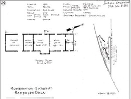
Even before the post office opened, however, the defining feature of Randolph had already appeared beside the tracks of the Frisco Railroad. In 1900, as the railroad completed its north–south corridor linking Indian Territory with the rail networks of Texas, the company erected a depot at Randolph. That stationlikelyrepresentedone of the earliest railroad depots in the immediate region and served as an important stop along the newly constructed line running between Sapulpa and Denison.
Fittingly, the community itself took its name from Thomas Randolph, a prominent official associated with the Frisco Railroad. During the railroad era, it was common for new towns to be named in honor of railroad executives, engineers, or investors whose influence helped guide the development of a line. The naming of Randolph reflected the close relationship between the emerging settlement and the railroad that brought it into existence.
When Frisco engineers surveyed the route southward across the prairie, they sought locations where stations could serve productive agricultural districts while maintaining practical spacing between depots. Randolph’s position near the fertileWashitaRiverbottoms made it a logical stop. The surroundingcountrysideproduced cotton and other crops that promised steady freight traffic, while the gently rolling terrain provided suitable ground for the construction of tracks, sidings, and station facilities.
The depot that rose beside the railroad in 1900 was typical of the small rural stations constructed by the Frisco during this era. Built largely of wood, the structure served both passenger and freight operations. Inside the building a waiting room provided shelter for travelers awaiting trains, while a separate freight room held shipments of goods arriving by rail before they were collected by local merchants or farmers.
At the center of the depot’s daily activity was the station agent, whose responsibilities extended far beyond selling passenger tickets. The agent managed freight records, coordinated shipments, and operatedthetelegraphequipment that connected Randolph with other stations along the railroad. Through the telegraph wires that followed the tracks across the prairie, messages could be transmitted instantly to distant towns, allowing railroad officials to coordinate train movements and enabling residents to communicate quickly with the outside world.
Around the depot additional railroad facilities soon appeared. A siding allowed freight cars to be positioned beside loading platforms where cotton bales could be stacked for shipment. Livestock pens held cattle awaiting transport to markets in Texas and beyond. Water tanks stood beside the tracks to supply the boilers of steam locomotives that paused briefly before continuing their journeys north toward the larger Frisco system or south toward Denison.
Randolph also gained significance as a point where the Frisco line intersected with tracks of the Chicago, Rock Island and Pacific Railway, creating a modest railroad junction in southern Johnston County. The presence of two railroads brought additional activity to the community, allowing freight and passengers to transfer between lines and increasing Randolph’s role as a rural trading center.
As the railroad station took root, businesses soon appeared nearby to serve the needs of both railroad workers and farmers from the surrounding countryside. Among the most prominent figures in the town’s early development was J. B. Chastaine, who became one of Randolph’s principal entrepreneurs. Chastaine established a number of enterprises that helped sustain the local economy, including a modern five-stand cotton gin capable of processing the cotton grown throughout the surrounding farms. Cotton gins were vital infrastructure in agricultural communities, separating cotton fibers from seeds before the bales were shipped by rail to distant markets.
Chastaine also operated a sawmill and planer that produced lumber used in building homes, barns, and businesses across the region. A gristmill ground grain into flour and meal for local residents. In addition, he ran a general store that he had purchased from an earlier merchant named Mr. Craig. Like many frontier stores, it served as both a commercial establishment and a social gathering place where farmers exchanged news and conducted the everyday business of rural life.
Life in Randolph revolved around the railroad depot and the businesses that surrounded it. During harvest seasons wagons loaded with cotton rolled into town from every direction. Farmers stacked their bales upon the loading platform and waited while the station agent recorded their shipments before they were loaded into freight cars. The arrival of a train was often an event in itself, drawing residents who gathered to watch the locomotive slow beside the depot or thunder past on its way south.
Records from around 1911 indicate that the Randolph station employed several railroad workers for both railroads, including clerks and telegraph operators who handled the steady flow of freight and communication passing through the depot. The station even had its own mascot—a dog known as “Muggie”—who reportedly becameafamiliarcompanion to the railroad employees working there.
Because Randolph stood so close to the boundary between Johnston and Marshall counties, its influence extended well beyond its official jurisdiction. Families living in northern Marshall County often relied upon Randolph for trade, transportation, and schooling. In the years following Oklahoma statehood in 1907, rural schools frequently served children from both sides of county lines, particularly in sparsely populated areas where settlements were widely scattered. Randolph’s location along the railroad naturally made it a gathering place for families throughout the surrounding countryside.
The broader community included areas such as Randolph Bottom along the Washita River, where early settlers built homes and even dugout dwellings along the fertile riverbanks. Long after the town itself faded, remnants of those early structures remained scattered across the landscape as reminders of the families who once lived there.
Like many early railroad settlements, Randolph eventually declined as economic activity shifted toward larger towns and transportation patterns changed. The closing of the post office in 1919 marked a turning point in the community’s history, and over time many of the buildings that once stood near the depot disappeared.
Though the railroad depot and post office eventually faded from Randolph, the quiet settlement would briefly return to regional headlines in the early 1950s through a strange and troubling episode involving a longtime local rancher.
During that time a cattleman named Robert L. “Bob” Rogers lived near Randolph, Oklahoma with his wife, Irene, operating a ranch in the fertile Washita River country that had supported farmers and ranchers in the area for decades. Rogers was widely known in both Marshall and Johnston Counties, where he had conducted business for many years. According to officials at the time, he had built a reputation over roughly twenty-five years as a man of honesty and integrity, maintaining good credit with banks in both Madill, Oklahoma and Tishomingo, Oklahoma. To many neighbors he was simply another well-established cattleman working the same Washita River country that had sustained the Randolph community since its earliest days.
Early in January of 1953, however, circumstances surrounding Rogers and his wife suddenly took a dramatic turn.
In its January 29, 1953, edition, the Madill Record reported that officers in both Madill and Tishomingo were searching for Rogers and his wife on charges of fraud and disposing of mortgaged property. A warrant for the arrest of the fifty-four-yearold rancher and his wife had been issued after local banks discovered that the security on which large loans had been issued had apparently vanished.
The Madill National Bank held mortgages on approximately 135 head of cattle and two motor vehicles totaling more than $10,000, while Rogers had also borrowed several thousand dollars from a bank in Tishomingo. When bank officials investigated Rogers’ ranch near Randolph, they discovered that the cattle and other pledged property had disappeared.
Shortly before the discovery, Rogers had mailed a letter from Oklahoma City, Oklahoma,datedJanuary10, to M. B. Bryant, president of the Madill National Bank. In that letter Rogers reportedly stated that he was unable to pay off his mortgages and suggested that the bank simply retrieve the collateral securing the loans. When investigators went to the ranch to examine that collateral, they reportedly found that the livestock and other security had vanished.
The news stunned many residents who had known Rogers for years. Marshall CountyAttorneyO.C.Barnes told reporters that Rogers had long maintained a reputation forhonestythroughout the region and had enjoyed good credit standing with banks in both Madill and Tishomingo. For a man whose business dealings had been trusted for decades, the sudden disappearance was difficult for many neighbors to comprehend.
Law enforcement officers in both counties began searching for the couple. Circulars describing Rogers and his wife were distributed across the region, and posters were circulated offering a $100 reward for information leading to their arrest. Authorities speculated that the pair might have traveled west, though no immediate confirmation of their location was reported.
As the weeks passed, the investigation widened. In its February 12, 1953, issue, the Madill Record reported that Gordon L. Kennedy, a special deputy from the Oklahoma Bureau of Investigation, had been assigned to assist local officials in locating the missing rancher and his wife. County Attorney Barnes statedthatcircularshadbeen sent out by county officers to track down the couple, who hadnotbeenheardfromsince early January.
Despite the warrants, the investigation, and the circulation of wanted notices, the trail soon grew cold. Newspaper reports noted that no information had been received regarding thewhereaboutsof Rogers or his wife after their sudden disappearance.
What ultimately became of Bob Rogers and his wife Irene remains uncertain. Contemporarynewspaperaccounts recordedthewarrants issued for their arrest, the investigation that followed, and the efforts of officers to locate the couple, yet the historical record grows silent after those early reports. No surviving documentation has been found that reveals whether they were ever apprehended or where their trail finally led. In the years that followed, the story passed quietly into local lore. Older residents of the Randolph and Washita Bottom communities sometimes spoke of the mystery with a wry expression common in the countryside, saying simply that “the hoot owls got them.”
Today, the story lingers as one of the many curious episodes that emerged from the fading years of Randolph. Longafterthedepotwasgone and the post office closed, the quiet prairie around the Washita River continued to hold traces of the community’s past—its railroad days, its early settlers, and the occasional mystery that left neighbors wondering what had truly happened. Though little remains of Randolph today beyond scattered ruins and historical records, the town holds an important place in the history of railroads insouthernOklahoma.
The depot erected there in 1900 represented one of the earliest footholds of the Frisco in the region and served as a gateway through which the railroad’s influence spread steadily southward across the prairie. For a time it stood as the focal point of activity in the Randolph community, where freight was loaded, passengers gathered, and the rhythms of railroad life shaped the surrounding countryside. After the station was eventually closed, the Frisco sold the depot building to a local farmer. The structure was moved to Russett, where it stood for many years before finally collapsing with age.
From Randolph, the rails continued across the prairie toward the place where the railroad would soon establish its most important station in Marshall County. There, beside the tracks crossing the open grassland of the Chickasaw Nation, the depot at Madill would rise and transform the surrounding prairie into the county’s principal railroad town. More on that in Part II.