
For generations before the first Europeans set foot in North America, the Chickasaw, Choctaw, Cherokee, Muscogee (Creek), Seminole and other Indian nations spanned from modern-day North Carolina to Mississippi. These people lived in relative peace for hundreds of years, growing corn, beans, squash, greens, tobacco and other crops. They hunted, fished, gathered wild plants, nuts and berries, and lived in relative peace. They also engaged in trade with each other and other villages and tribes. However, all this changed in the early 16th century with the arrival of European exploration and colonization.
The Europeans brought with them diseases that killed thousands of Indians, and others were killed or enslaved by Spanish explorers who led expeditions throughout the Southeast. This then led to the combination of different Indigenous groups into larger tribes. The weak joined the strong to survive.
With colonization came a desire to convert Native Americans to Christianity and to force them to adopt European cultures and traditions. These efforts were more successful in the Southeast than in other parts of North America. Because of the partial adoption of European cultures and traditions, the Chickasaw, Choctaw, Cherokee, Muscogee (Creek) and Seminole Nations were dubbed the “Five Civilized Tribes.” But as more and more white settlers began moving into the Southeast part of North America in the late 18th century, they began pressuring the U.S. Government to push Native Americans out of their lands.
In 1830, Congress passed the Indian Removal Act, which allowed President Andrew Jackson to remove the Native Americans from Southeast North America. In 1831, with the Treaty of Dancing Rabbit Creek, the Choctaw people were forced from their ancestral lands in Mississippi. The Seneca, Shawnee and Ottawa also were part of this removal.
In 1832, the Treaty of Payne’s Landing began the processofremovingtheSeminole people from Florida. Also, in 1832, the Treaty of Pontotoc Creek in Mississippi required the removal of the Chickasaw from their lands. Then, the Sac and Fox Nation, the Prairie Band of Potawatomi people, and the Shawnee and Delaware tribes ceded lands for land in Kansas. Other tribes ceded their lands for land in Illinois and Missouri. The small nations of Stockbridge, Munsee, Brotherton and New York Oneida ceded lands and were relocated to the northeast corner of Indian Territory.
In 1833, the Quapaw of Arkansas were removed to Indian Territory, and the Apalachicola of Florida (part of the Muscogee-Creek Confederacy) alsobeganremoval. Then, the Indian Intercourse Acts designated the territories west of Missouri, Arkansas, andLouisianaas“Indian Territory.” Indian Territory at this time extended from the Red River of Texas north to the Canadian border. Also, in1834,theMuscogeeNation began removal. In 1835, The Treaty of New Echota provided forremovingallCherokees east of the Mississippi River, and the Seminoles of Florida began removal, as did the Muscogee and Creek.
Then, in 1837, the Chickasaw National voluntarily left their ancestral lands and settled on the western fringe of the Choctaw Nation in Indian Territory. In 1838, the forced removal of 16,000 Cherokees began. In 1839, the Cherokee Trail of Tears continued, incurring approximately 4,000 deaths along the way, and in 1842, FortWashitawasestablished in Indian Territory.
By 1867, Indian Territory was reduced to the areas in present-day Oklahoma, and the Sac and Fox were removed from Kansas to the Indian Territory along with the Citizen Potawatomi Nation. Then, the Treaty of Medicine Lodge was concluded, reassigning the Cheyenne and Arapaho reservations to the Indian Territory. In 1869, Fort Sill was established in southwestern Indian Territory, and in 1871, the Osage in Kansas purchased land from the Cherokee Nation, creating the Osage reservation in present-day Osage County. In 1874, the Pawnee wereremovedfromNebraska and moved to the Indian Territory.
Between 1877 and 1880, the Ponca were removed from Nebraska to Indian Territory, and the Iowa were removed from Nebraska and Kansas to Indian Territory. Then, in 1880, the Boomer Movement, started under David L. Payne, to open the Unassigned Lands in central Indian Territory for settlement purposes. This generated discussion among the Cherokee and Muscogee to attempt to thwart Payne’s efforts. But in 1884, David Payne died in Wellington, Kansas, and second-in-command William Couch took over.
Thisledtothe1887General Allotment Act, authored by US Senator Henry L. Dawes. The Dawes Severalty Act (General Allotment Act) legislated the allotment of communal tribal lands into individually owned tracts of land. To aid in the full assimilation of its Indian population, the U.S. Congress created the Dawes Commission in 1893. Another congressional law, enacted on June 28, 1898, was sponsored by Charles Curtis, a mixed-blood Kansa Indian and senator from Kansas. With the passage of the Curtis Act, Congress took final control over affairs in Indian Territory.
The Curtis Act helped weaken and dissolve Indian Territory tribal governments by abolishing tribal courts and subjecting all persons in the territory to federal law. This meant that there could be no enforcement of tribal laws and that any tribal legislation passedafter1898had to be approved by the president of the United States. Towns could be surveyed and incorporated under the act, andresidentswerepermitted to vote. The establishment of public schools was also sanctioned.
With the passage of the Curtis Act, Congress authorized theDawesCommission to prepare new citizenship rolls for each tribe. Sen. Henry L.DawesofMassachusetts compiled a census to be used as the basis for the allotment of tribal lands to individual Indians. The ensuing allotment was performed without tribal consent.
The Curtis Act dealt a blow to the governmental autonomy of the Five Tribes. Still, the act was merely the culmination of legislation designed to strip tribal governments of their authority and give it to Congress or the federal government. Ironically, Charles Curtis, himself of Indianblood,wasresponsible for the act that helped pave the way for the demise of the Indian nations. The Dawes Act was passed by Congress, thus establishing the Dawes Commission and the beginning of the plans to dismantle IndianTerritory. In1889,the Unassigned Lands in what is now Oklahoma were opened to settlement in the first of five land runs. This led to the establishment of The Oklahoma Territory in 1890.
The ultimate purpose of the Curtis Act was to pave the way for statehood for the combined Indian and Oklahoma Territories. The Act provided an eight-year time frame for the abolishment of tribal governments, with the plan for statehood commencing in 1906.
By 1903, the “Five Civilized Tribes” opposed all efforts for a combined Indian Territory and Oklahoma Territory state. However, with the end of tribal governments looming on March 4, 1906, as prescribed by the Curtis Act, those tribes devised a plan.
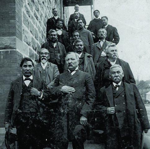
Beginning in 1905, an Indian-led attempt to secure separate statehood for Indian Territory began. On August 21, 1905, the Sequoyah Convention convened in the HintonTheaterinMuskogee, Creek Nation, to propose to Congress statehood for Indian Territory. The state was tobenamed“Sequoyah”after Cherokee Indian Sequoyah, who created the Cherokee syllabary, enabling reading and writing in Cherokee. Sequoyah’s accomplishment was one of the few times in recorded history that an individual member of a preliterate group created an original, effective writing system.
At the instigation of Cherokee citizen James A. Norman, in early July 1905, W. C. Rogers, principal chief of the Cherokee Nation, and Green McCurtain, chief of the Choctaw Nation, called the convention to draft a constitution for a proposed stateandtoselectanameand capital city. Delegates were chosen for mass meetings held across the Indian Territory. InlateJuly,anamended call included the names of Creek Chief Pleasant Porter and Seminole Chief John F. Brown. Chickasaw Governor Douglas Johnston opposed the movement, forcing the other delegates to select William H. Murray, future Oklahoma governor and intermarried Chickasaw, to represent the Chickasaws before and during the convention.
Reconvening on October 14, 1905, at South McAlester, the convention authorized Chair Pleasant Porter and SecretaryAlexander Poseyto sign the constitution for the delegates. The approximately thirty-five-thousand-word constitution was perhaps the convention's greatest contribution toOklahoma’shistory. It had many similarities to thelaterOklahomaConstitution, sharing an underlying populist distrust of elected officials. The convention also catapulted Murray and others further into the public arena, securing a solid seat for Indian Territory at the debate later at the Oklahoma Constitutional Convention, a goal that Chair Porter made clear from the outset.
Territorial leaders realized that the Republican-led U.S.Congresswouldunlikely admit a heavily Democratic Indian Territory. Yet, singlestate supporters and Indian nation leaders pressed the campaign in the weeks leading up to the November 7, 1905, election. Turnout was light, with 56,279 votes for the constitution and petition to Congress and 9,073 votes against. Early in the Fiftyninth Congress, Rep. Arthur Phillips Murphy of Missouri, who also acted as attorney for the Creek Nation, and Sen. Porter James McCumber of North Dakota filed Sequoyah statehood bills.
Article XII of the proposed State of Sequoyah's Constitution established the state's counties, totaling forty-seven. While similar to the county boundaries ultimately laid out when Oklahoma became a state, the counties of the State of Sequoyah bore different names. The counties names and major communities in those counties were: Cheadle County included the communities of Francis, Allen, Stewart, Conway, Calvin, and Newberg.
MosleyCountycoveredthe communities of Stonewall, Tupelo, Lehigh, Colgate, and Onley.
Washington County included the communities of Thackerville, Brock, Marietta, Overbrook and Cheek.
Bixby County included Atoka, Limestone Gap, Standing Rock, Boggy Depot, Farris and Wesley.
Blue County was home to the communities of Caddo, Burney, Bentley, Armstrong and Caney.
Tom Needles County covered the communities of Durant,Wade,Blue,Roswell, Sterrett, Kemp, Bokchito, Colbert, Bennington and Roberts.
Hitchcock County included FortTowson,Valliant, Hugo, Soper, and more.
Johnston County encompassed Randolph, Troy, Tishomingo, Milburn, Connerville, Ravia, Nida, Mill Creek, Mannsville, Belton, Wapanucka and Pontotoc.
Byrd County covered Ada, Roff, Franks, Hickory, Bebee, Center, Hart, Midland, and York.
Harris County was home to Leon, Courtney, Hewitt, Lone Grove, Simon, Cornish, Dixie, Orr, Grady, Keller, Sneed and Healdton.
Jefferson County included the communities of Terrell, Addington, Opic, Ryan, Fleetwood, Woolsey, Oscar and Linwood.
Gilbert County held Comanche, Loco, Duncan, Parks, Hope, Marlow, Velma and Bradley.
Bonaparte County had Rush Springs, Lindsey, Alex, Agawan, Purcell, Mayesville, Minnihaha, Bradley, Naples, Story, Malvern, and Ireton.
Rutherford County included Spiro,Howe,Panama, Shady Point, Poteau and Wister.
Spokogee County included Holdenville, Wetumka, Weeletka, Aqua, Timber, Bear Den and Fertress.
Cussehta County covered Henryetta,Grayson,Hasson, Dustin, Burney, Schultler, Senora and Bryant.
Eufaula County included Eufaula, Checotah, Crowder City, Canadian, Brush Hill Mellette and Indianola.
Tulladega County held Bristow, Olive Mannford and Depew.
Okmulgee County housed Lee, Haskell, Nuyaka, Morris, Sharp Bald Hill, Okmulgee and Wealska.
Tumechichee County included Wagoner, Tullahassee, Gibson Station Inola, Hulbert and Turner.
Euchee County included Sapulpa, Mounds, Kelleyville, Beggs, Tuskogee, Tulsa, Drake Red Fork and Tabor.
Coweta County included Veer, Porter, Choska Valley, Coweta, Fry, Springton Evans, Broken Arrow, Clarksville and Red Bird.
Coo-wee-coo-wee County held, Talala, Catoosa, Owasso, Claremore,Foyil,Oolagah and West Chelsea.
Mayes County had Adair, Pryor, Creek, Choteau, Spavinaw, Big Cabin, Chelsea, Locust Grove and Salina.
DelawareCountyincluded Kansas,Zena,Eucha,Cleora, and Leach.
Flint County held Westville, Proctor, Oak Grove, Stilwell, Salem, Bollard and Hungry Mountain.
TahlequahCountyencompassed Whitemore, Hanard, Bug Tucker, Lowry, Odell, Pegga,Cookson,ElmSprings and Tahlequah.
Sequoyah County held Campbell, Pawpaw, Vian, Muldrow, Sallisaw, Roland, Marble City, Cane, Akin Redland and Black Gum.
Breckenridge County included Webbers Falls, Porum, Russell, Txana and Muskrat.
Quapaw County included Wyandotte, Cayuga, Afton, Miami, Needmore, Quapaw, Fairland,Peoria,Ottawaand Narcissa.
CherokeeCountyincluded Vinita, White Oak, Catalee, Blue jacket, Wellch, Estalla, Hudson, Kinnison and Wasson.
Thomas County had Tumaha,Garland,Keota,Eagle Point, Fanshaw, Blaine, Cowlington, Stigler, Bokoshe, Red Oak, Walls, Chant, Lods, Victor and Saylor.
Garvin County included Pauls Valley, Wayne, Johnson, McGee,Klondike,Whitehead, Wynnewood, Iona, Paoli, Byers Chise, Coulson, Walker, and Brady.
Guy County covered Purdy, Royal Alsa, Elk, Antioch, Boyle,Monk,Homer,Elmore, Robberson, Fox and Hennepin.
McLish County included Ardmore,Dougherty,Springer, Buckhorn, Durwood, Davis, Palmer, Nebo, Berwyn, Glenn Springer and Baum.
San Bois County included Kinita, Hoyt, San Bois, Quinton, Whitefield, Brooken, Enterprise and Ninee.
Hailey County had Massey,Dwight,Hartshorne, Demon, Haileyville, Holson, Carbon Gowen, blanco and Wilburton.
TobuskeyCountyincluded Kiowa, South McAlester, Savanna, McAlester, Krebs, Frink, Whites, Alderson, Scipio and Celestine.
McCurtainCountyincluded Bethel, Eaggleton, Glover, Idabel, Beach, Smithville, Lukfate, Janis Shawnetown, Harrington,Goodwater,Harris, Pollard and Hochatown.
Push-ma-th-ha County included Alikchi, Big-Lick, Hosome, Pleasant Cave, Surphur Springs, Tuskahoma, Muse, Talahina, Page, and Antlers.
Wade County covered Heavener, Panola, Albion, Thomasville, Sammerfield and Telahina.
Lenahpa County included Nwata, Alluewe, Owen, Coody’s Bluff, Lenapah, Wetova, and more.
Skiatook County covered Dewey, Skiatook, Ochalata, Bartlesville Collinsville, Ramona, Vera and Oglesby.
SeminoleCountyincluded Wewoka, Sasakwa, Konowa, Little, Wolfe, Lima and Tidmore.
Arbeka County covered Okemah, Creek, Newby, Boley, Morse, Paden, and Okfuskee.
Curtis County included Dibble, Newcastle, Amber, Pocassett, Minco, Tuttle, and Chickasha And finally, Overton County, which included Tyler, Willis, Lone Elm, Kingston, Linn, Woodville, Meade, Shay, Lebanon, Weaverton, Cumberland, Platter, Silo, Powell, Oakland, Isom Springs, Kinlock, Aylesworth, Robber’s Roost, Simpson and Madill.
For the next year, the area covering Madill, Kingston, Willis and the other communities making up what is now Marshall County, was known as Overton County. Newspaper articles, ads, stories and more declared the area Overton County. This name continued until late 1906 when the United States Congress refused to consider the creation of the State of Sequoyah. Then, on November16,1907,Congress passed legislation creating theStateofOklahoma,which combined Indian Territory and Oklahoma Territory into one state. This was the end that was feared by the Five Civilized Tribes. When the new state was established, the county map was reshuffled, and most counties were named after white men. Had the State of Sequoyah been established, Madill and Kingston would be part of Overton County today.
In an ad in the Madill News on October 27, 1905, the citizens of Overton County were instructed to vote at one of the following precincts, Aylesworth, Isom Springs, Kingston, Lone Elm, Madill, Oakland, Platter, Silo, Shay, Willis, Weaverton, Cumberland, Kinlock,Linn,Lebanon, Mead, Powell, Roberts Roost, Simpson, Tyler or Woodville.
For the next one hundred and thirteen years, all hopes for a separate Indian state were dashed. However, in 2020, the United States Supreme Court, in the case of McGirt vs. Oklahoma, reaffirmed the reservations of the Five Civilized Tribes. That case reaffirmed the sovereignty of the Indian nations over their lands and people, a principle inherent in the Sequoyah Statehood movement.
Did the story end in 1907, or could the five tribes revive their plan for a separate state? It’s an interesting question. Could Marshall CountyonedaybecomeOverton County? Not likely, but it is an interesting thought. But just for fun, tell your friends and family you are from Overton County.